Category Archives: Patterns

State Economic Trends

.. examining state quarterly GDP trends, 2023 update .. the BEA state quarterly Gross Domestic Product (about GDP) estimates are among the more important regional economic time series. These estimates provide a comprehensive measure of the state level economy and have only a 3-month lag between reference data and data of availability.

California had the highest real GDP among all states over the year 2022Q1-2023Q1. Texas follows close behind and experienced the highest rate of growth in real GDP among all states over the same period. Two states experienced a decline in real GDP over the year. How will state and regional GDP components change over the next five years? What policy actions might affect this and how, when? Learn more in the next blog update on predicting outcomes using statistical models.

Examining Patterns of 2023Q1 per Capita Real GDP by State
Use the “no login” version of VDA Web GIS to examine patterns of 2023Q1 per capita real GDP by state as illustrated in the following graphic. Nothing to install. Start VDA Web Base here. See more about VDA Web Base. Click graphic for larger view.

How State GDP is Changing
Use this interactive table to learn more about how state GDP is changing. View, sort, examine GDP time series attributes: real GDP, real GDP indexes, current GDP. State GDP matters as it tells us about how the aggregate economy is changing by region. But stakeholders need more than just recent data. More needs to be known about the current situation, how things might change and how change might impact demographic-economic outcomes in the future.

About VDA GIS
Use VDA GIS tools to meet wide-ranging mapping needs and geospatial analysis. VDA Desktop GIS and VDA Web GIS have similar features that can be used separately or together. Each is a decision-making information resource designed to help stakeholders create and apply insight. VDA Web GIS is access/used with only a Web browser; nothing to install; GIS experience not required. VDA Desktop GIS is installed on a Windows computer and provides a broader range of capabilities compared to VDA Web GIS. VDA GIS resources have been developed and are maintained by Warren Glimpse, ProximityOne (Alexandria, VA) and Takashi Hamilton, Tsukasa Consulting (Osaka, Japan).

Data Analytics Web Sessions
Join us in the every Tuesday, Thursday Data Analytics Web Sessions. See how you can use VDA Web GIS and access different subject matter for related geography. Get your geographic, demographic, data access & use questions answered. Discuss applications with others.

About the Author
Warren Glimpse is former senior Census Bureau statistician responsible for national scope statistical programs and innovative data access and use operations. He is also the former associate director of the U.S. Office of Federal Statistical Policy and Standards for data access and use. He has more than 20 years of experience in the private sector developing data resources and tools for integration and analysis of geographic, demographic, economic and business data. Join Warren on LinkedIn.

School District Geography & GeoSpatial Analysis

.. the approximate 100,000 K-12 public schools, 13,000 school districts and 50 million school age children in the United States touch nearly every dimension of society and the economy. This section reviews the scope of school district geography as cachement areas for the K-12 public schools and school age population .. and tools to examine them in an integrated and holistic manner. How does school district instructional expenditure relate to the demographic-economic make-up of the district? Educational outcomes? How are leaders and educators equipped to make effective use of these tools and data?

School districts are geographic areas covering the U.S. to provide public K-12 education. I developed the first national scope school district boundary file in the mid-1990s, a joint project of the U.S. National Center for Education Statistics and the Census Bureau. School district boundaries are now updated annually as a part of the Census Bureau TIGER digital map database under the sponsorship of the U.S. National Center for Education Statistics (NCES). School district names, codes, enrollment by grade and many other attributes are updated annually as a part of the NCES Common Core of Data (CCD). The 2021-22 (latest data as of this time) school district CCD administrative data provides data for approximately 13,025 “regular” school districts. The CCD data are one type of data that can be merged (based on a common key of the NCES assigned local education ID) with TIGER-based school district shapefiles that can enable mapping and geospatial analysis. Using these shapefiles with Geographic Information System (GIS) software users can examine maps of districts by name, view boundaries or patterns such the per pupil instructional expenditure.

Types of School Districts
School districts, whose boundaries and operations are defined and managed by individual states, often exist as three types of school districts in differing combinations: elementary, secondary and unified. Some states have only unified school districts that are also the same as the counties (such as Florida, Kansas, Maryland and Nevada). California has perhaps the most complex array of mixed elementary, secondary and unified districts.

Huntington Beach, CA School Districts
The following view shows how 4 elementary districts (orange boundaries) each offering grades K-8 education collectively cover the same ground area as 1 secondary district, Huntington Beach Unified High School District (green bold boundary) offering grades 9-12 education.

K-12 School & School District GIS Project
The VDA GIS ready to use K-12 School & School District GIS project with CV XE GIS, VDA Desktop GIS or the VDA Web GIS to examine and geospatially analyze school districts and school district attributes in context of other geography and subject matter. For example, the following view shows patterns of neighborhood economic prosperity (median household income by census tract) for the Huntington Beach, CA school districts. Click graphic for larger view.

Viewing Your School District
To view your school district, follow these steps:
Start VDA Web GIS
Select the “K-12 Schools & School Districts” project.
When the map view opens
.. uncheck School District Elementary and School District Secondary
    in Legend Panel at left
Enter address in Search box above map (Apple Headquarters in this example)
Press enter and this view appears .. click blue triangle to view profile.
.. see that this district is Santa Clara Unified ..

About VDA GIS
There are two VDA GIS tools that have similar features that can be used separately or together. Each is a decision-making information resource designed to help stakeholders create and apply insight. VDA Web GIS is access/used with only a Web browser; nothing to install; GIS experience not required. VDA Desktop GIS is installed on a Windows computer and provides a broader range of capabilities compared to VDA Web GIS. VDA GIS resources have been developed and are maintained by Warren Glimpse, ProximityOne (Alexandria, VA) and Takashi Hamilton, Tsukasa Consulting (Osaka, Japan).

Data Analytics Web Sessions
Join us in the every Tuesday, Thursday Data Analytics Web Sessions. See how you can use VDA Web GIS and access different subject matter for related geography. Get your geographic, demographic, data access & use questions answered. Discuss applications with others.

About the Author
Warren Glimpse is former senior Census Bureau statistician responsible for national scope statistical programs and innovative data access and use operations. He is also the former associate director of the U.S. Office of Federal Statistical Policy and Standards for data access and use. He has more than 20 years of experience in the private sector developing data resources and tools for integration and analysis of geographic, demographic, economic and business data. Join Warren on LinkedIn.

Accessing & Using Census 2020 Data 06.04.23 Update

.. effective late May 2023, stakeholders (all of us) now have access to the Census 2020 decennial population and housing data. More than three years after the reference date for Census 2020, detailed demographic data are now available to better understand demographic characteristics for a very wide range of geography to the census block level. Visit our Census 2020 data access and use section, updated continuously, to facilitate more effective use of these data.

While the Census Bureau released the Census 2020 “P.L. 94-171” redistricting data two years ago, the new “Demographic and Housing Characteristics” (DHC) data contain much more extensive data. For example, the P.L. 94-171 data contains no gender data. The P.L. 94-171 data has only one age break — 18 years and over. The DHC data, the focus of this section, includes data by single year of age 0, 1 .. 110 and over iterated by gender and race/origin. And much more.

Get started accessing Census 2020 data now. Use this API link to access Census 2020 data on the size of the urban and rural population by county. Clicking that link opens a new page showing a row for each county with the urban and rural population. The first data row (row 2) shows that in Bullitt County, Kentucky, the total population was 82,217 with 58,002 urban and 24,215 rural. The state+county FIPS code is 21029. From here, build a spreadsheet file or geospatially map/analyze these data. More on this, step-by-step, in the next Census 2020 blog.

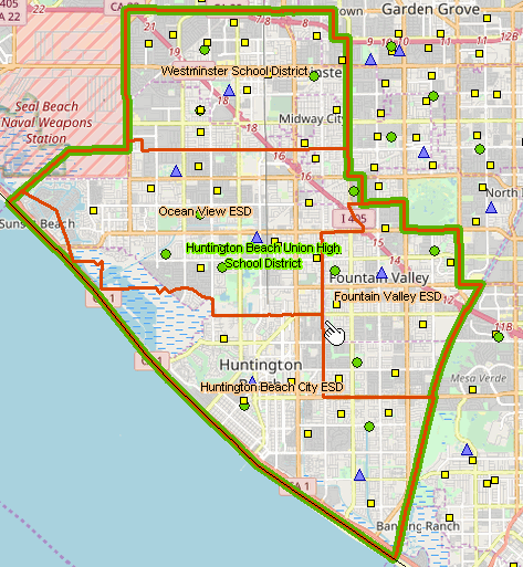
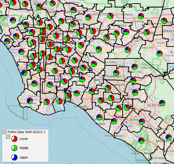
Examine the distribution of Millennials by census tract using Census 2020.
The following view illustrates use of DEDE to extract Census 2020 single year of age data and then create a thematic pattern map showing the distribution of percent Millennials by census tract. in the New York region. This static view is a snapshot of using VDA GIS tools to map these patterns nationally. It is evident from this view that Millennials are smaller part of the population in the Bronx, Queens, and south Kings County. Further insights are available. This matters, for example, in knowing about the where and how the Millennial population is distributed for analyses of the voting population and prospective outcomes. Many similar applications.

Comparing ACS with Census 2020 Data
Aren’t the American Community Survey 2021 (ACS2021) data more recent than the Census 2020 data? In general, no. The ACS 2021 data (the now most recent ACS-sourced data) are tabulated for 2021 only for selected types of geography with 65,000 population and over — the ACS 1-year data. For most counties, most cities, most school districts, all census tracts, all ZIP Code areas and other geography .. only the ACS 5-year estimates are available. These estimates are for the five-year period 2017 through 2021 .. centric to mid-2019. Two-thirds of the ACS 2021 respondents are pre-pandemic.

Comparing ACS with Census 2020 Data – Subject Matter
The ACS data include a much richer set of demographic subject matter compared to Census 2020. For example, ACS includes income, education, employment and data on many other topics. This compares to the more limited subject matter covered by Census 2020 — population, age, gender, race/origin, housing units, selected housing unit attributes. ACS estimates are all subject to sampling and related estimation errors. Census 2020 data are counts. Many ACS estimates are suppressed, and the data item value is not available (such as median household income for a census tract). There is no suppression with Census 2020 data — the data can always be aggregated (for example, the sum of census block group items for an entire county or state).

Census 2020 provides single year of age data by gender by race/origin for census tract and higher level geography. ACS provides data for selected age groups. As a result, only using the Census 2020 data can we tabulate point, one year, data on the number of Millennials and Generation-Z population groups.

Comparing ACS with Census 2020 Data – Geography
The ACS smallest area of data tabulation is the block group. The Census 2020 smallest area of data tabulation is the census block. One advantage of the Census 2020 census block data availability is the size being smaller, more granular than a block group. Possibly the more important use of census block data is the ability to aggregate custom sets of blocks into an aggregated area such as Congressional Communities or user defined study/service areas.

Accessing/Using Census 2020 Data
The Census Bureau provides the online service data.census.gov and the Census Bureau API access the Census 2020 data. The Demographic-Economic Data Explorer (DEDE enables users overcome some limits of the Census API and create Geographic Information System GIS friendly datasets. The Visual Data Access (GIS) tools provide immediate online access to Census 2020 data with only a browser — enabling mixed subject matter and geography for a wider range, or basic, applications/analyses.

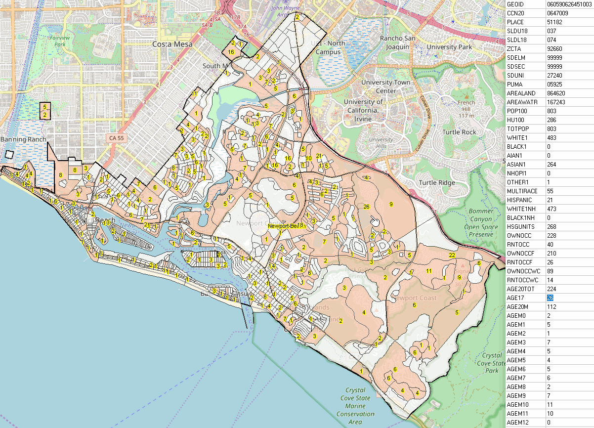
This graphic illustrates use of VDA Web GIS to show patterns of the age 17 population by block (salmon colored blocks, label with population 17 years or age) in Newport Beach, CA. Create maps like this for other areas. Login and start now .. select the County/Regional Trends project.

About VDA GIS
VDA Web GIS is a decision-making information resource designed to help stakeholders create and apply insight. Use VDA Web GIS with only a Web browser; nothing to install; GIS experience not required. VDA Web GIS has been developed and is maintained by Warren Glimpse, ProximityOne (Alexandria, VA) and Takashi Hamilton, Tsukasa Consulting (Osaka, Japan).

Data Analytics Web Sessions
Join us in the every Tuesday, Thursday Data Analytics Web Sessions. See how you can use VDA Web GIS and access different subject matter for related geography. Get your geographic, demographic, data access & use questions answered. Discuss applications with others.

About the Author
Warren Glimpse is former senior Census Bureau statistician responsible for national scope statistical programs and innovative data access and use operations. He is also the former associate director of the U.S. Office of Federal Statistical Policy and Standards for data access and use. He has more than 20 years of experience in the private sector developing data resources and tools for integration and analysis of geographic, demographic, economic and business data. Join Warren on LinkedIn.

Measuring & Analyzing Households by Social Class by PUMA

.. a social class is a population or household group typically referred to as a lower, middle and upper class. The size of the population or households in a social class is often determined in relationship to an interval related to the median household income of an area — from two-thirds of median household income to twice the median household income (MHI). Subsequent blog posts will address a broader definition for class determination. By better understanding composition and determinants of social class for an area, we might better understand and improve on income inequality and create new opportunities. This is a multi-part blog post on social class analytics. Click Follow at right to receive updates.

Percent Population in Households by Social Class by PUMA
.. Los Angeles area .. click for larger view.

Los Angeles metro area by social class .. PUMAs shown with black boundaries; pointer at Los Angeles-Orange County line

Percent of Households by Social Class by PUMA
.. Los Angeles area .. click for larger view.

Los Angeles metro area by social class .. PUMAs shown with black boundaries; pointer at Los Angeles-Orange County line

Using American Community Survey Microdata
We use of the American Community Survey microdata or “public use microdata samples” (PUMS) http://proximityone.com/pums.htm to develop estimates of population and households by middle class, lower class and upper class by “public use microdata area” (PUMA) http://proximityone.com/puma.htm. Microdata files are comprised of anonymized individual respondent data within PUMAs. The approximate 2,800 PUMAs cover the U.S. wall-to-wall and must have 100,000 population or more. 2010 and 2020 vintages PUMAs may be examined and compared with other geography using the VDA Web GIS http://proximityone.com/vda.htm with the MetroDynamics Project.

Social Class Participation by PUMA
Using custom software, the PUMA (ACS 2021 1 year data in this case), individual housing records are summarized for each PUMA. An estimate is developed for the lower, middle and upper class based on an algorithm.

Examine patterns of social class stratification using VDA Web GIS anywhere in U.S.
The estimates are then integrated into a PUMA shapefile. The PUMA shapefile is added to a Geographic Information System (GIS). Access this shapefile/layers using VDA Web GIS to examine patterns of social class, such as the graphics shown above, or in combination with other geography and subject matter.

About VDA GIS
VDA Web GIS is a decision-making information resource designed to help stakeholders create and apply insight. Use VDA Web GIS with only a Web browser; nothing to install; GIS experience not required. VDA Web GIS has been developed and is maintained by Warren Glimpse, ProximityOne (Alexandria, VA) and Takashi Hamilton, Tsukasa Consulting (Osaka, Japan).

Data Analytics Web Sessions
Join us in the every Tuesday, Thursday Data Analytics Web Sessions. See how you can use VDA Web GIS and access different subject matter for related geography. Get your geographic, demographic, data access & use questions answered. Discuss applications with others.

About the Author
Warren Glimpse is former senior Census Bureau statistician responsible for national scope statistical programs and innovative data access and use operations. He is also the former associate director of the U.S. Office of Federal Statistical Policy and Standards for data access and use. He has more than 20 years of experience in the private sector developing data resources and tools for integration and analysis of geographic, demographic, economic and business data. Join Warren on LinkedIn.

Examining City GeoDemographic Drilldown; Intersecting Tracts and Places

.. how can “our city” do a better job of providing housing for low-income individuals and families? One part of a successful program involves looking at attributes of the neighborhood, or census tract, geography across the city. We need to analyze needs by city component census tracts, areas averaging 4,000 population. Here is how that might be approached — determining which census tracts. And while this applies to low income housing, it applies to many other planning topics.

Relate census tract geography to city/place geography using GIS tools for analytical purposes … determine which tracts intersect a city/place. This section considers intersecting tracts and places for illustrative purposes. But the methodology, and tools to do this, involve many, many other types of geography .. geographic spatial intersection. The inputs in this case are U.S. national scope 2020 census tracts (85,190 areas covering the U.S. wall-to-wall) and U.S. national scope 2020 places (32,188 areas). The output from the process of intersecting these geographies are tract-place intersecting parts (119,906 areas). There are 32,146 tracts that are wholly contained in places.

Developing Intersect Files
Tracts intersecting with cities can be determined using the VDAGIS Intersect tool. Select the two input shapefiles and name the intersect output shapefile. The intersect shapefile is added to the GIS project being used.

Focusing on a City
What tracts intersect a city of interest? By having this information, stakeholders, policymakers can study and better understand inequities, differences and needs across the city. Consider Santa Ana, CA (Orange County). There are 65 tracts that intersect with the city of Santa Ana. This could be any city across America. The following view shows Santa Ana with intersecting tracts.

By viewing the intersecting file in VDAGIS, intersecting tracts can be examined. The graphic below shows a zoom-in to tract 06059089102 (blue boundary). This tract is shown at the pointer in the above graphic. in the following zoom-in view, the white label shows the tract code for the whole tract and the two split parts are shown with the same code. The part to the right in Santa Ana city, the part to the left is in Garden Grove city.

Using the intersecting file, the list (a partial list) of these tracts and tract codes can be determined as shown below. By knowing the tract codes, detailed demographic-economic data can be pulled using DEDE and tract characteristics can be studied. Inequities ab be examined, special needs can be determined, east versus west tract groups might identify patterns to facilitate collaboration and policy development. What are the patterns of affordable housing across the city?

About VDAGIS
VDA Web GIS is a decision-making information resource designed to help stakeholders create and apply insight. Use VDA Web GIS with only a Web browser; nothing to install; GIS experience not required. VDA Web GIS has been developed and is maintained by Warren Glimpse, ProximityOne (Alexandria, VA) and Takashi Hamilton, Tsukasa Consulting (Osaka, Japan).

About the Author
Warren Glimpse is former senior Census Bureau statistician responsible for national scope statistical programs and innovative data access and use operations. He is also the former associate director of the U.S. Office of Federal Statistical Policy and Standards for data access and use. He has more than 20 years of experience in the private sector developing data resources and tools for integration and analysis of geographic, demographic, economic and business data. Join Warren on LinkedIn.

Population Living Alone & Age 65 Years and Over

.. how many people are living alone in your community, neighborhood? How does this population impact the community? What are their special needs? How does this population vary by area and population group? There were 37.9 million one-person households, 29% of all U.S. households in 2022. In 1960, single-person households represented only 13% of all households. These estimates are based on the 2022 Current Population Survey (CPS). Moving forward, the number of one-person households, people living alone, will increase at the rate of one million or more per year. People in households exclude people living in group quarters. This post examines patterns of people living alone with focus on people living alone age 65 year and over and distribution by small area geography.

While the CPS data provide a current snapshot of the number of people living alone, we have to use data from the American Community Survey to obtain data for smaller area geography like counties and census tracts.

Population Living Alone by Census Tract –Visual Data Analytics
The four graphics below show patterns of the population living alone by census tract. These views have been developed using the Visual Data Analytics (VDA GIS) tools with integrated demographics. Develop variations on these views using the VDA Web GIS using only a web browser.

Patterns of Population Living Alone by Tract

.. click graphic for larger view.

Patterns of Population 65 and Over Living Alone by Tract

.. click graphic for larger view.

Patterns of Population Living Alone by Tract — Houston Metro Area

Patterns of Population 65 and Over Living Alone by Tract — Houston Metro Area

Examine the Data in More Detail
As noted in this related New York Times story, nearly 26 million Americans 50 or older now live alone, up from 15 million in 2000. Older people have always been more likely than others to live by themselves makes up a bigger share of the population than at any time in the nation’s history. The trend has also been driven by deep changes in attitudes surrounding gender and marriage. People 50-plus today are more likely than earlier generations to be divorced, separated or never married. Similar ACS data as used to develop the graphics shown above are available by race/origin. These data are based on the ACS 2020 data; the same scope of data will be available from ACS 2021 to be released in December 2022.

About VDA GIS
VDA Web GIS is a decision-making information resource designed to help stakeholders create and apply insight. Use VDA Web GIS with only a Web browser; nothing to install; GIS experience not required. VDA Web GIS has been developed and is maintained by Warren Glimpse, ProximityOne (Alexandria, VA) and Takashi Hamilton, Tsukasa Consulting (Osaka, Japan).

About the Author
Warren Glimpse is former senior Census Bureau statistician responsible for national scope statistical programs and innovative data access and use operations. He is also the former associate director of the U.S. Office of Federal Statistical Policy and Standards for data access and use. He has more than 20 years of experience in the private sector developing data resources and tools for integration and analysis of geographic, demographic, economic and business data. Join Warren on LinkedIn.

Housing Price Index by ZIP Code – How Housing Markets are Trending

.. housing prices can impact residential investment and affect economic growth, business opportunities and the housing market. The Housing Price Index (HPI) is one measure of how housing prices are changing. The HPI by ZIP code, as reviewed here, is an index based on the year 2000=100. Changing trends in the HPI can used used the determine the relative costs of housing and change in housing valuation. Hosing prices, and the HPI, are only one part of determining how housing markets are trending. Other measures important to examine include building permits and new construction.

Examining Housing Price Trends
Use the VDA Web GIS tool to examine the Housing Price Index for ZIP Codes of interest. Create maps and tabular profiles such as the one shown below.

Video of Steps to Explore HPI by ZIP Code
Click graphic to view video showing how to use VDA Web GIS to access a ZIP Code profile.

About VDA Web GIS
VDA Web GIS is a decision-making information resource designed to help stakeholders create and apply insight. VDA Web GIS has been developed and is maintained by Warren Glimpse, ProximityOne (Alexandria, VA) and Takashi Hamilton, Tsukasa Consulting (Osaka, Japan).

About the Housing Price Index
The Housing Price Index used here is developed by the Federal Housing Fiance Agency (FHFA). The FHFA House Price Index is the nation’s only public, freely available house price indexes that measure changes in single-family home values based on data from all states that extend back to the mid-1970s.

About the Author
Warren Glimpse is former senior Census Bureau statistician responsible for national scope statistical programs and innovative data access and use operations. He is also the former associate director of the U.S. Office of Federal Statistical Policy and Standards for data access and use. He has more than 20 years of experience in the private sector developing data resources and tools for integration and analysis of geographic, demographic, economic and business data. Join Warren on LinkedIn.

Examining Age/Gender Distributions with Population Pyramids

Population pyramids provide a data visualization often used in demographic analysis because they provide a condensed but powerful illustration of a population’s age distribution by gender. You can use the ChartGraphics tool to create population pyramids for the U.S., states, counties and other areas as reviewed in this section. For example, examine Census 2020 population by 5-year age group by gender for your area of interest.

A population pyramid is essentially two bar charts, one for the male population on the left and the other for the female population on the right. The base of the pyramid, or bottom of the chart, has the youngest population (ages 0-4) and the top has the oldest (ages 85 and older). The following pyramids illustrate how Orange County, CA has changed from 2000 to 2020.


.. click here to view above graphic and table.


.. click here to view above graphic and table.

About the Author
Warren Glimpse is former senior Census Bureau statistician responsible for national scope statistical programs and innovative data access and use operations. He is also the former associate director of the U.S. Office of Federal Statistical Policy and Standards for data access and use. He has more than 20 years of experience in the private sector developing data resources and tools for integration and analysis of geographic, demographic, economic and business data. Join Warren on LinkedIn.

Arizona’s Shifting Demographics

.. part of a state-by-state series .. these periodic posts examine how and why the state and its counties changed bwteen 2010 and 2020. Later posts will provide more of a drill-down look at change. Click the Follow link at right to receive new and updated information.

Census 2020 Arizona Demographics
The Arizona July 1, 2020 Census model-based population estimate of 7,421,401 compares to the Census 2020 population count of 7,151,502 people. The difference of -269,899 between the 2020 estimate and the 2020 count can be explained by several factors. First, the estimate is for a point in time that is three months later that the Census. There will be a tendency of the Census Bureau to adjust the Joly 1, 2020 population estimate to conform to the Census 2020 value. The July 1, 2020 estimate will likely be adjusted to reflect this change when the July 1, 2021 estimates are released April/May of 2022.

The 2020 population estimate is determined using a component method. The 2020 population estimate is the sum of the 2019 population estimate (7,291,843 for Arizona) and each of the following for the period July 1, 2019 through June 30, 2020 …
plus births (AZ 81,451)
less deaths (AZ 66,385)
plus international migration (AZ 9,272)
plus domestic migration (AZ 105,435)
plus an estimation residual (AZ -214)

Any one or a combination of these 6 estimate based values could be wrong, or the Census 2020 value could be wrong. It is likely a combination of all of these factors.

The remainder of this section is based on Census Bureau model-based estimates, released April 26, 2021. See more about these data for all U.S. counties in the Demographics 2060 section where Arizona demographic projections can be examined.

Visualizing Arizona Demographic Change
The following graphic illustrates how Arizona county demographics have changed from 2010 to 2020. The labels show the actual percent change; the color patterns, as shown in the legend, provide a visual thematic pattern view.

Examining the How and Why of Demographic Change
The following table shows a row for the state and each county, providing more detail as to the where, what/how much, how and why demographic change has occurred from 2010 to 2020.


Click graphic for larger view.

Looking Ahead
More geographically detailed data (counties for example) based Census 2020 (August 2021) will reveal much starker percentage differences between the 2020 estimates versus Census results. The ProximityOne annual estimates and projections to 2060 are developed using two basic series (and variation among those (low, base, high): Census 2020 based series and 2020 estimates series. See http://proximityone.com/demographics2060 for details.

Learn more — Join me in the Data Analytics Web Sessions
Join me in a Accessing & Using GeoDemographics Web Session where we discuss topics relating to measuring and interpreting the where, what, when, how and how much demographic-economic change is occurring and it’s impact.

About the Author
— Warren Glimpse is former senior Census Bureau statistician responsible for national scope statistical programs and innovative data access and use operations. He is also the former associate director of the U.S. Office of Federal Statistical Policy and Standards for data access and use. He has more than 20 years of experience in the private sector developing data resources and tools for integration and analysis of geographic, demographic, economic and business data. Contact Warren. Join Warren on LinkedIn.

Census 2020 – First Results

.. the first results of Census 2020, the apportionment data, were released on April 26, 2021.  Based on the decennial census, the United States total resident population increased from 308,745,538 (2010) to 331,449,281 (2020), a change of 22,703,743 (7.3%). For now, these data should be trusted and assumed accurate.  The apportionment data provide only total population counts at the state level.  More will be revealed about the accuracy of these data when the redistricting data are released in August 2021.

Apportionment of the U.S. House of Representatives
Congressional apportionment is the process of dividing the 435 members, or seats, in the House of Representatives among the 50 states based on the population data from the decennial census. See more about congressional districts and demographic-economic characteristics. See this related web section for detailed information on apportionment. Use the interactive table to view/analyze the Census 2010 and Census 2020 apportionment data. The following view shows patterns of congressional seats based on the decennial census. Labels show the number of seats based on the 2020 Census. Color patterns show the change in seats, 2010 to 2020.

Census 2020: the Process & Challenges
Counting the total population and selected population attributes in a pandemic is not only challenging but not possible.  During 2020, as the data were collected, it seemed good news that more than two-thirds of the potential respondents had completed the questionnaire.  But then the questions set in.  Bureau public announcements frequently made reference to the number or housing units and the number of households (occupied housing units) “accounted for” reaching 90 percent and progressively more.  By observation, using administrative record data, and other methods, housing units can be much more easily counted than the population and population attributes.  Likewise, determining the number households is  easier than determining the population count and characteristics.

The fact that the state population counts were unexpectedly different from the Bureau’s model based estimates is troubling.  We seek more assurance that the count of  population and population characteristics — by location — are as represented by the apportionment data.

Census Bureau 2020 Model-Based Estimates
New Census Bureau sourced U.S. by county model-based population estimates by age/gender/race-origin as of July 1, 2020 will be released by the Bureau in May 2021.  These estimates are independent of Census 2020 and make use of methods used annually throughout the 2010-2020 period.  An upcoming blog will report on ProximityOne’s analysis of these estimates in comparison with the Census 2020 data.

ProximityOne Estimates & Projections to 2060
ProximityOne annual demographic estimates and projections 2010-2060 by county will begin a new update cycle in May 2021.  The schedule is shown here.  

Starting with the May updates, two base projection series will be developed and progressively updated: one controlled to the Census 2020 data and one based on continued use of 2020 model-based estimates. As more information is released from Census 2020. Follow this blog for more information on evolving developments.

Learn more — Join me in the Data Analytics Web Sessions
Join me in a Accessing & Using GeoDemographics Web Session where we discuss topics relating to measuring and interpreting the where, what, when, how and how much demographic-economic change is occurring and it’s impact.

About the Author
— Warren Glimpse is former senior Census Bureau statistician responsible for national scope statistical programs and innovative data access and use operations. He is also the former associate director of the U.S. Office of Federal Statistical Policy and Standards for data access and use. He has more than 20 years of experience in the private sector developing data resources and tools for integration and analysis of geographic, demographic, economic and business data. Contact Warren. Join Warren on LinkedIn.