Monthly Archives: January 2017

National Children & Education Statistics Program Updates

.. NCES Program updates .. tools, data & methodology to examine national scope children & education .. school, school district & extended geographic-statistical data with drill-down to school and intersection level. See more about the NCES Program below.

New this Week
ACS 2015 school district demographic-economic interactive tables
– view, compare, analyze selected/all U.S. school districts
– more focused blog updates coming soon.

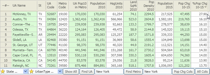
School Districts with Highest Median Household Income
Use the interactive table to examine economic characteristics of school districts. Below is a list of the 10 school districts having the highest median household income developed using the Economic Characteristics interactive table. Develop similar views for metros and states of interest.

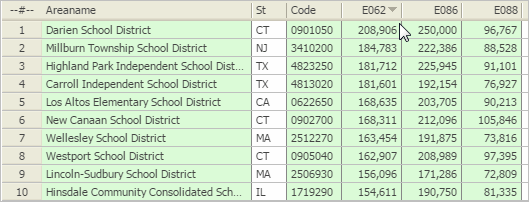
– ranked on item E062 — median household income.
– click graphic for larger view.

Use GIS tools to develop thematic pattern maps such as the one shown below with NCES GIS projects. Select from hundreds of statistical measures. Create your own regional;/district views. Integrate other data.

Patterns of Economic Prosperity by School District
– median household income (item E062 in table)

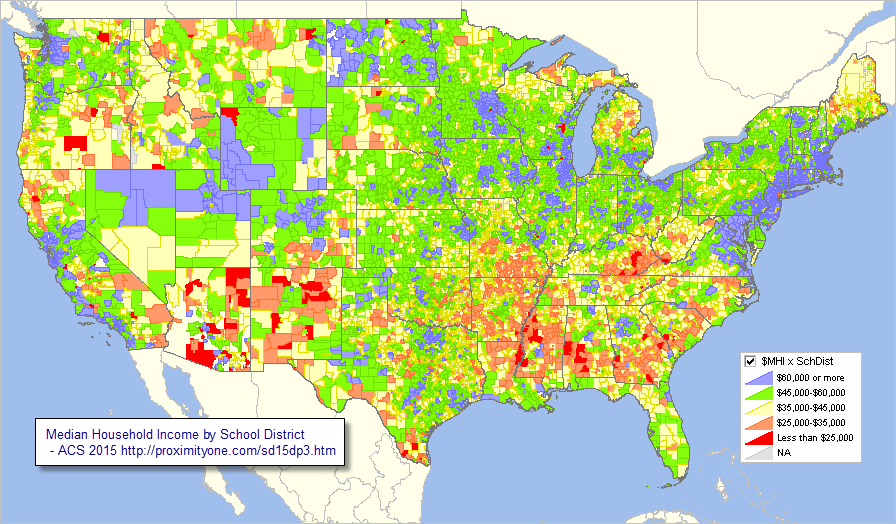
– view developed with CVGIS software & related GIS project and data.
– click graphic for larger view.

See the School Districts Economic Characteristics Interactive Table.

About the National Children & Education Statistics Program
The National Children & Education Statistics (NCES) Program provides access to tools, data & methodology to examine national scope children’s demographics & education-related characteristics. These resources enable stakeholders to view and analyze detailed geographic and statistical data at the school, neighborhood, community, attendance zone, school district and higher level geography. Integrate these data with drill-down demographic-economic data to the census block and intersection levels. Examine characteristics of schools, school districts and education data with related and higher level geography including urban/rural, cities, counties, metros, state and the U.S.

See NCES Main Section.

Contents: Summary of NCES Program Resources
Click a link to view more detail on a selected topic.
Updates: New Resources, Events & Related Topics
Analytics, Blogs, Studies
Using Software Tools & Datasets
01 Mapping & Visual Analysis Tools
02 School District Annual Demographic-Economic Data Resources
03 Children’s Demographics & Living Environment by School District
04 School District Enrollment & Operational Characteristics
05 School District Finances: Sources & Uses of Funds
06 School District Geographic Size & Characteristics
07 School District-ZIP Code Area Relationship Table
08 K-12 Public Schools
09 K-12 Private Schools
10 K-12 Public School Attendance Zones
11 K-12 Public Schools by Urban/Rural Status
12 Census Tract Demographic-Economic Characteristics
13 Metropolitan Area Situation & Outlook Reports

Join me in a Data Analytics Lab session to discuss more details about accessing and using wide-ranging demographic-economic data and data analytics. Learn more about using these data for areas and applications of interest.

About the Author
— Warren Glimpse is former senior Census Bureau statistician responsible for innovative data access and use operations. He is also the former associate director of the U.S. Office of Federal Statistical Policy and Standards for data access and use. He has more than 20 years of experience in the private sector developing data resources and tools for integration and analysis of geographic, demographic, economic and business data. Contact Warren. Join Warren on LinkedIn.

Urban Area Demographic Trends 2010-15

.. tools and analytics to examine all urban areas with particular focus on Urbanized Areas and demographic change between 2010 and 2015 .. examining urban areas in context of metropolitan areas .. the four fastest growing Urbanized Areas (UAs) from 2010 to 2015 were in Texas. McKinney, TX UA led the nation with an increase of 27.5% in total population. View, rank, compare 2010 and 2015 demographic characteristics for UAs using the interactive table in this related section. Urban areas (Urbanized Areas and Urban Clusters) are important for many reasons. More than metros and cities, urban area geography better reflects how the urban and rural population is changing. Both metros and cities can change geographic boundary over the years. Urban areas are based on Census 2010 and unchanging between 2010 and 2020. Annual demographic updates are available from the American Community Survey (ACS 2015).

This section is focused on tools and analytics to examine all urban areas with particular focus on Urbanized Areas and demographic change between 2010 and 2015. Use the interactive table >in the related section to view, rank, query urban areas and demographic change for larger urban areas. Use the related GIS tools and data to develop related thematic and relationship maps. Perform geospatial analysis of geographic and demographic-economic characteristics using the resources we have developed. Gain insights into patterns that might affect you. Use these resources to collaborate on how, where, what, when and why of change.

McKinney TX Urbanized Area in Context of City
The McKinney, TX UA (bold orange pattern) is shown in context of McKinney city (cross-hatched area) and other urban areas (lighter orange pattern). It is easy to see that some parts of the city are rural and that the UA extends beyond the city in many areas. See more about the McKinney UA and in comparison to other urban areas using the interactive table.


– view created using CVGIS software and related GIS project.

Most Urbanized Areas (UAs, 435 of 487) have population 65,000 population or more resulting in the availability of annual demographic-economic estimates. Data are fresher than available for smaller urban areas (ACS 5-year estimates for areas under 65,000). This means more current data to assess more recent characteristics. As annual data are available UAs enabling analysis of change over time. The “2010s” marks the first time these refreshed, time series-like data have been available for urban areas. Businesses and those examining change performing market analysis benefit from the ability to examine characteristics or urban areas in combination with counties and metros.

Houston Urbanized Area in Context of Houston Metro
The Houston metro has a bold brown boundary. It is easy to see how the Houston UA (darker orange fill pattern) geographically relates to the metro. Other urban areas (all) are shown with a lighter orange fill pattern. It is easy to see the urban/pattern character of the general region. While the Houston UA is the largest, there are four UAs that intersect with Houston metro. Use the interactive table below to view their names and characteristics.


– view created using CVGIS software and related GIS project.

Urbanized Areas tend to be associated with metropolitan areas having a similar name. But very often there are multiple UAs within a metro; sometimes one is not dominant. Often there are several UAs in a metro having similar size. Use the interactive table below to view the relationship of UAs and metros (CBSAs).

Using Interactive Table
Use the interactive table to view, rank, compare, query urban areas based on a selection of demographic measures. The following graphic illustrates how the table can be used. Click graphic for larger view.

The graphic shows the urbanized areas ranked in descending order based on 2010-2015 population. The rightmost column shows the area percent change in population over the period.

Fastest Growing Urbanized Areas, 2010-15

Try it yourself. Use the table to examine urban area patterns and characteristics based on your selected criteria.

Join me in a Data Analytics Lab session to discuss more details about accessing and using wide-ranging demographic-economic data and data analytics. Learn more about using these data for areas and applications of interest.

About the Author
— Warren Glimpse is former senior Census Bureau statistician responsible for innovative data access and use operations. He is also the former associate director of the U.S. Office of Federal Statistical Policy and Standards for data access and use. He has more than 20 years of experience in the private sector developing data resources and tools for integration and analysis of geographic, demographic, economic and business data. Contact Warren. Join Warren on LinkedIn.

Creating Maps & GIS Projects

.. follow these steps to create custom maps & GIS projects .. while maps are “everywhere,” there is a continuing need to make new maps. Reasons for this include changing underlying geography, new features (like stores or customers to be viewed), visually examining geographic relationships not available elsewhere (e.g., census tracts and ZIP codes), different geographic depictions for an area (smoothed versus precise vertices) and other reasons. A map can provide view(s) that relate to geospatial analysis; map visualization can be indispensable (showing road features adjacent to selected properties).

View of Initial Map Objective — University Park, TX; Dallas Metro area
Census tracts (black boundary) shown with census tract code as label.

— view developed using CV XE GIS software

Follow steps in this section to make a map like above for any area in the U.S. This section provides an overview of how to use the CVGIS software to quickly build a map. It is actually more than a map, it is the process of building a GIS project. A map is one rendering that can be displayed, and optionally published, using a GIS project. Map/GIS project development steps reviewed here can be performed using the no fee CVGIS software and no fee data resources, CVGIS Levels 1 and higher can save the GIS project and have additional geography available. With geographic extension, the process illustrated here can work for any place in the world. A GIS project is a file itself that contains references to map files (shapefiles) located on your computer. Once a GIS project has been created and saved, it can be immediately opened with CVGIS using the File>Open operation. After turning your computer off, and restarting it, the GIS project can be re-opened to display the same view as saved in an earlier session.

No Previous GIS/Mapping Experience Required
This section is designed for use by anyone including those with no previous GIS/mapping experience. Requirements are a Windows computer and Internet access. This section is a part of a module used in the Certificate in Data Analytics and the CVGIS Certification Programs. Developers can also benefit from this and related tutorials to learn more about how GIS can be integrated with other data analytics tools and methods.

Making Maps Steps
The objective of this session is to develop a map (and GIS project) to view characteristics of census tract “48113019301”. The first step in making a map (GIS project) is to have a clear objective. This 11 character geocode uniquely identifies this Census 2010 census tract among all other 73,057 tracts in the U.S. See more about census tract geography and geocodes. While this application shows a process for adding only two layers, it could be extended by adding more. Similarly, while this application uses a census tract boundary files (shapefile), alternatives are census blocks, block groups, ZIP code areas, among others.

These steps should take an inexperienced user 10-15 minutes to develop a new CVGIS project view. If anything becomes confused, close the program and start over.
Step 1. Install CVGIS (1/1/2017 or later version)
Step 2. Open Base Project
Step 3. Get Census Tract Shapefile
Step 4. Get Roads Shapefile
Step 5. Modify Map View
Step 6. Optionally Save GIS Project

The view should now be similar to the view at the top of this section.

Next Steps
Try the process yourself with geography of interest to you. View/use other “Creating Maps & GIS Projects” tutorials to learn about:
• integrating subject matter
• developing and using thematic maps
• creating site profiles

Join me in a Data Analytics Lab session to discuss more details about accessing and using wide-ranging demographic-economic data and data analytics. Learn more about using these data for areas and applications of interest.

About the Author
— Warren Glimpse is former senior Census Bureau statistician responsible for innovative data access and use operations. He is also the former associate director of the U.S. Office of Federal Statistical Policy and Standards for data access and use. He has more than 20 years of experience in the private sector developing data resources and tools for integration and analysis of geographic, demographic, economic and business data. Contact Warren. Join Warren on LinkedIn.