Monthly Archives: October 2018

How the New York Metro is Changing

.. or more precisely, how the New York Metropolitan Statistical Area (MSA) is changing. As of Census 2010 the New York MSA (officially the New York-Newark-Jersey City, NY-NJ-PA MSA) consisted of 20 counties. With the new OMB metropolitan statistical areas defined as of February 2013, the New York MSA became 22 counties, absorbing the Poughkeepsie, NY MSA two counties (Dutchess and Orange). The Poughkeepie MSA was removed from the official MSAs. The delineation remained that way until the new September 2018 delineations when the Census 2010 delineation was restored. Now, the Poughkeepsie, NY MSA exists as a 2 county area and the New York MSA exists as a 20 county area (both as they existed geographically in Census 2010).

These metro-county relationships are shown in the graphic presented below. The Poughkeepsie, NY MSA is shown with the blue cross-hatch to the north and the New York MSA is shown with the salmon color pattern.

– view developed using the CV XE GIS software and related GIS project.
– see the related New York Metro Situation & Outlook report.

What Difference Does it Make?
A lot! First, during the interim period 2013-2018, the Poughkeepsie, NY MSA lost the metropolitan area identity/status as conferred by the OMB delineations. It might have been omitted from size class market development and research analyses. Related, that metro was not included as a tabulation or estimation area of MSAs by Federal statistical agencies. An example of the impact is that the official demographic estimates for the Poughkeepsie, NY MSA developed by the Census Bureau were not tabulated as such and omitted from various statistical reports. Also, the removal of designation and now adding the designation back, creates a hiccup in the time series — affecting both the Poughkeepsie NY MSA and the New York MSA.

Detailed Demographic Profiles for New York MSA and Poughkeepsie, NY MSA
.. click link to view profile.

New York-Newark-Jersey City, NY-NJ-PA MSA
  Bergen County, NJ (34003)
  Essex County, NJ (34013)
  Hudson County, NJ (34017)
  Hunterdon County, NJ (34019)
  Middlesex County, NJ (34023)
  Monmouth County, NJ (34025)
  Morris County, NJ (34027)
  Ocean County, NJ (34029)
  Passaic County, NJ (34031)
  Somerset County, NJ (34035)
  Sussex County, NJ (34037)
  Union County, NJ (34039)
  Bronx County, NY (36005)
  Kings County, NY (36047)
  Nassau County, NY (36059)
  New York County, NY (36061)
  Putnam County, NY (36079)
  Queens County, NY (36081)
  Richmond County, NY (36085)
  Rockland County, NY (36087)
  Suffolk County, NY (36103)
  Westchester County, NY (36119)
  Pike County, PA (42103)

Poughkeepsie-Newburgh-Middletown, NY (CBSA 39100)
  Dutchess County, NY (36027)
  Orange County, NY (36071)

Looking Forward
The September 2018 CBSA delineations define counties that will be used for Census 2020 (likely, there could be yet further changes) — 384 MSAs in the U.S. In the cases of the New York MSA and the Poughkeepsie, NY MSA, it appears that the geography (component counties) used for Census 2010 will be the same as for Census 2020. Going forward, ProximityOne estimates and projections will use the most current vintage of CBSAs.

Data Analytics Web Sessions
Join me in a Data Analytics Lab session to discuss more details about accessing and using wide-ranging demographic-economic data and data analytics. Learn more about using these data for areas and applications of interest.

About the Author
— Warren Glimpse is former senior Census Bureau statistician responsible for innovative data access and use operations. He is also the former associate director of the U.S. Office of Federal Statistical Policy and Standards for data access and use. He has more than 20 years of experience in the private sector developing data resources and tools for integration and analysis of geographic, demographic, economic and business data. Contact Warren. Join Warren on LinkedIn.

Examining the Situation & Outlook

.. this blog focuses on topics regarding the current situation and outlook .. what is happening now, historical trends and into the future .. demographic and economic characteristics for wide-ranging types of geography .. what will change where, when, by how much .. and how change might it impact you .. data resources and tools enabling a deeper dive; relating to decision-making and management. Access, analyze data with only a browser using VDA Web GIS. Get email updates with new posts as they happen … click Follow button at right.

U.S. House of Representatives 2020 Apportionment

.. Congressional Apportionment by State .. 2010 & projected 2020 state by state congressional seats.

What will the results of Census 2020 tell us us about how the House of Representatives will be reapportioned, state by state? This section examines scenarios which might occur based on state population projections. See related Web section http://proximityone.com/apportionment.htm for more detail and interactive table.

Use the GIS tools and project to make your own map views … see details
.. use in classroom .. research .. reference .. collaboration.

This section has been developed using
– 2020 apportionment population projections
.. part of the ProximityOne Situation & Outlook (S&O)
– the reapportionment/redistricting feature of the CV XE GIS software
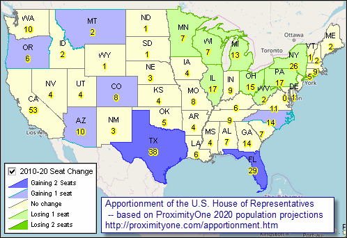
The 2020 population projections reflect anticipated change under one scenario. Those values are then used in the CV XE GIS reapportionment operation to compute the number of House seats shown in the related table.

Apportionment of the U.S. House of Representatives
— based on the 2010 Census

– view created with CV XE GIS. Click graphic for larger view with more detail.

Apportionment of the U.S. House of Representatives
— based on ProximityOne 2020 Population Projections

– view created with CV XE GIS. Click graphic for larger view with more detail.

Congressional apportionment is the process of dividing the 435 memberships, or seats, in the House of Representatives among the 50 states based on the population figures collected during the decennial census. The number of seats in the House has grown with the country. Congress sets the number in law and increased the number to 435 in 1913. The Constitution set the number of representatives at 65 from 1787 until the first Census of 1790, when it was increased to 105 members. More about apportionment.

Initial Census 2020 demographic data, the apportionment data, will be released by December 31, 2020. See related Census 2010 Apportionments.

Apportionment totals were calculated by a congressionally defined formula, in accordance with Title 2 of the U.S. Code, to divide among the states the 435 seats in the U.S. House of Representatives. The apportionment population consists of the resident population of the 50 states, plus the overseas military and federal civilian employees and their dependents living with them who could be allocated to a state. Each member of the House represents, on average, about 710,767 people for Census 2010.

Using the Interactive table
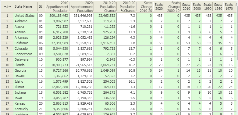
The following graphic illustrates use of the 2010 & 2020 apportionment by state and historical apportionment 1910 to 2010. Sort on any column; compare apportionment patterns over time. Click graphic for larger view.
Use the interactive table at http://proximityone.com/apportionment.htm#table.

Congressional District/State Legislative District Group
Join the CDSLD Group (http://proximityone.com/cdsld.htm), a forum intended for individuals interested in accessing and using geodemographic data and analytical tools relating to voting districts, congressional districts & state legislative districts and related geography with drill-down to intersection/street segment and census block level. Receive updates on topics like that of this section.

Data Analytics Web Sessions
Join me in a Data Analytics Lab session to discuss more details about accessing and using wide-ranging demographic-economic data and data analytics. Learn more about using these data for areas and applications of interest.

About the Author
— Warren Glimpse is former senior Census Bureau statistician responsible for innovative data access and use operations. He is also the former associate director of the U.S. Office of Federal Statistical Policy and Standards for data access and use. He has more than 20 years of experience in the private sector developing data resources and tools for integration and analysis of geographic, demographic, economic and business data. Contact Warren. Join Warren on LinkedIn.
New 2018 Vintage Metropolitan Areas

.. new, September 14, 2018 vintage, Core-Based Statistical Area (CBSA) delineations have been released by the U.S. Office of Management and Budget (OMB).  Among other things, the new delineations specify which counties are included in each CBSA.  CBSAs. an OMB standards term, are metropolitan areas comprised of Metropolitan Statistical Areas (now 384 MSAs in the U.S.) and Micropolitan Statistical Areas (now 542 MISAs in the U.S.).

How Metros Change Geographically
The following graphic, focused on the Charlotte, NC-SC MSA region, illustrates how MSAs are changing. 2017 vintage MSAs are shown with bold green boundary, yellow fill pattern. Cross-hatched areas are 2018 vintage MSA counties. As of the 2018 vintage, note that …
• Anson County, NC (to right of pointer) has been added to the Charlotte, NC-SC MSA.
• Union County, SC has been removed from the Spartanburg, SC MSA.
• Harnett County, NC has been added to the Fayetteville, NC MSA.

— graphic developed using CV XE GIS software and related GIS project.

What About My MSAs of Interest?
See detailed information about the 2018 vintage CBSAs/MSAs and their component counties at http://proximityone.com/cbsa2018.htm.

Impact of the 2018 Delineations
The new delineations take place immediately and have numerous impacts.  Going forward, Federal statistical agencies will develop statistics and use the new names and geocodes as set forth in the new delineations (most names and geocodes remain the same).  For CBSAs affected, which are numerous, this will result in challenges for longitudinal analyses where consistently defined geography over time is required.  The total 2017 official population estimates are affected for three of the largest 10 CBSAs using the 2018 delineations compared to the 2017 delineations.  More immediately, it may become confusing whether the 2018, 2017, 2015, or an earlier vintage CBSA geography is being referenced.  On a positive note, the 2018 vintage CBSAs are believed to best reflect the set of counties comprising a CBSA as an entity of highly related demographic-economic conditions.

Keeping Up-to-Date with Metro Demographic-Economic Data
Metropolitan Statistical Areas (MSAs/metros), comprised of one or more contiguous counties, are important for many reasons. Business, demographic and economic data for these 384 areas, each developed around an area of large population concentration, provide a “10,000 foot” view of these characteristics and how they are changing. As they are comprised of county groups, much of the subject matter data are also available for drill-down analysis at the county and sub-county levels. Metro boundaries change some over time … as more peripheral counties are added or removed depending on their demographic-economic affinity with central county(s).

Metros are an important part of the ProximityOne Situation & Outlook program. Metro demographic-economic estimates and projections are updated to reflect 2018 vintage metros. This includes all elements of the Census-sourced age-race/ethnicity-gender annual estimates and American Community Survey demographic-economic subject matter.

Designating Metros and Delineating Metro County Components
More detail … in consultation with Federal statistical agencies, OMB defines metropolitan statistical area boundaries. This section provides a summary of Metropolitan Statistical Areas (MSAs), and component Metropolitan Division and Counties/County Equivalents, as delineated in OMB Bulletin 18-04 issued September 14, 2018. These delineations take place immediately. This is a significant update affecting approximately 20-percent of previous MSA delineations (one or more county addition or removal).

Under the September 14, 2018 delineation, there are 938 Metropolitan Statistical Areas (MSAs) and Micropolitan Statistical Areas (MISAs) in the U.S. and Puerto Rico, collectively referred to as Core-Based Statistical Areas (CBSAs). There are 392 MSAs (384 in the U.S. and 8 in Puerto Rico). 11 MSAs contain a total of 31 Metropolitan Divisions. There are 546 MISAs (542 in the United States and 4 in Puerto Rico).

The 384 U.S. MSAs comprise 1,181 counties of total 3,142 U.S. counties. The total 2017 population of these metros was 280,468,904 of total 325,719,178 U.S. population (86.1%).

See related sections:
• Metros Main Section
• Metros Situation & Outlook Reports
.. click link in column 3 in table in above page to view detailed report
• Metro Demographic-Economic Interactive Tables
• County Population/Components of Change Interactive Table

Data Analytics Web Sessions
Join me in a Data Analytics Lab session to discuss more details about accessing and using wide-ranging demographic-economic data and data analytics. Learn more about using these data for areas and applications of interest.

About the Author
— Warren Glimpse is former senior Census Bureau statistician responsible for innovative data access and use operations. He is also the former associate director of the U.S. Office of Federal Statistical Policy and Standards for data access and use. He has more than 20 years of experience in the private sector developing data resources and tools for integration and analysis of geographic, demographic, economic and business data. Contact Warren. Join Warren on LinkedIn.