Tag Archives: Census

Examining Chinese Demographics by Census Tract

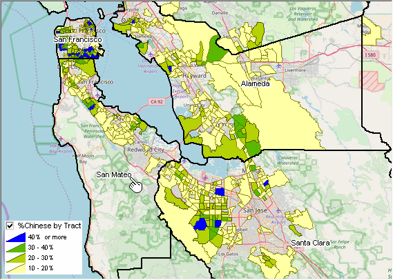
.. the 2021 U.S. Chinese (except Taiwanese) resident population estimate was 4,103,036 of total U.S. population 331,893,745 (1.25%) based on the ACS 2021 1-year data — a small percentage. But when examined by census tract many areas have a relatively large Chinese population. The focus of this section is on tools and data to examine patterns and characteristics of the Chinese population by 2020 census tract. To facilitate these analyses, a new Mapping Statistical Data project (MSD 071123) has been developed and is available to CV XE GIS and VDA Desktop users. The project has been used to develop the map graphic shown below. Develop similar drill-down views for other regions using these tools/data. The GIS project enables examining other characteristics of the Chinese population by census tract. The Chinese population is one of several population groups that can be studied in this manner.

Patterns of Percent Chinese Population by Census Tract in the San Francisco Area
The following graphic shows a thematic map of the percent Chinese population by tract in the San Francisco area. See the inset legend showing colors representing percent intervals.

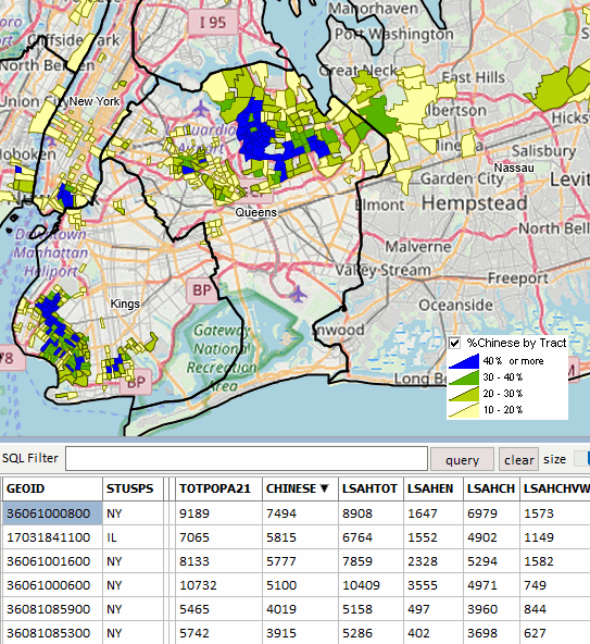
Patterns of Chinese Population by Census Tract in the New York City Area
Tracts with the largest Chinese population are mainly in New York City as shown in the graphic below. Using the VDA table feature the “Chinese” field is ranked in descending order. Tract 36-061-000080 has the largest Chinese population among all tracts, 7,494.

About VDA GIS
There are two VDA GIS tools that have similar features that can be used separately or together. Each is a decision-making information resource designed to help stakeholders create and apply insight. VDA Web GIS is access/used with only a Web browser; nothing to install; GIS experience not required. VDA Desktop GIS is installed on a Windows computer and provides a broader range of capabilities compared to VDA Web GIS. VDA GIS resources have been developed and are maintained by Warren Glimpse, ProximityOne (Alexandria, VA) and Takashi Hamilton, Tsukasa Consulting (Osaka, Japan).

Data Analytics Web Sessions
Join us in the every Tuesday, Thursday Data Analytics Web Sessions. See how you can use VDA Web GIS and access different subject matter for related geography. Get your geographic, demographic, data access & use questions answered. Discuss applications with others.

About the Author
Warren Glimpse is former senior Census Bureau statistician responsible for national scope statistical programs and innovative data access and use operations. He is also the former associate director of the U.S. Office of Federal Statistical Policy and Standards for data access and use. He has more than 20 years of experience in the private sector developing data resources and tools for integration and analysis of geographic, demographic, economic and business data. Join Warren on LinkedIn.

Block Group Demographic Data Analytics

.. use tools described here to access block group data from ACS 2016 (or ACS2017 in December 2018) using a no cost, menu driven tool accessing the data via API. Select from any of the summary statistic data. Save results as an Excel file or shapefile. Add the shapefile to a GIS project and create unlimited thematic pattern views. Add your own data. Join us in a Data Analytics Web session where use of the tool with the ACS 2017 data is reviewed.

See related Web section for more details.
– examine neighborhoods, market areas and sales territories.
– assess demographics of health service areas.
– create maps for visual/geospatial analysis of locations & demographics.

Illustration of Block Group Thematic Pattern Map – make for any area

– click graphic to view larger view
– pointer (top right) shows location of Amazon HQ2

Topics in this how-to guide (links open new sections/pages)
• 01 Objective Thematic Pattern Map View
• 02 Install the CV XE GIS software
• 03 Access/Download the Block Group Demographic-Economic Data
• 04 Download the State by Block Group Shapefile
• 05 Merge Extracted Data (from 03) into Shapefile (04)
• 06 Add Shapefile to the GIS Project; Set Intervals
• 07 Viewing Profile for Selected Block Group
• 08 BG Demographics Spreadsheet
• 09 Block Group Demographics GIS Project
• 10 Why Block Group Demographics are Important

Data Analytics Web Sessions
Join me in a Data Analytics Lab session to discuss more details about accessing and using wide-ranging demographic-economic data and data analytics. Learn more about using these data for areas and applications of interest.

About the Author
— Warren Glimpse is former senior Census Bureau statistician responsible for innovative data access and use operations. He is also the former associate director of the U.S. Office of Federal Statistical Policy and Standards for data access and use. He has more than 20 years of experience in the private sector developing data resources and tools for integration and analysis of geographic, demographic, economic and business data. Contact Warren. Join Warren on LinkedIn.

State of the States: Demographic Economic Update

.. tools and resources to examine the demographic-economic state of the states .. in 2016, the U.S. median housing value was $205,000 while states ranged from $113,900 (Mississippi) to $592,000 (Hawaii). See item/column H089 in the interactive table to view, rank, compare, analyze state based on this measure … in context of related housing characteristics. These data uniquely provide insights into many of the most important housing characteristics.

Use new tools, data and methods to access, integrate and analyze demographic-economic conditions for the U.S. and states. These data will update in September 2018.

Approximately 600 subject matter items from the American Community Survey ACS 2016 database (released September 2017) are included in these four pages/tables:
• General Demographics
• Social Characteristics
• Economic Characteristics
• Housing Characteristics

GIS, Data Integration & Visual Data Analysis
Use data extracted from these tables in a ready-to-use GIS project. These ACS sourced data (from the four tables listed above) have been integrated with population estimates trend data, components of change and personal income quarterly trend data. See details in this section.

Examining Characteristics & Trends
Below are four thematic pattern maps extracted from the main sections listed above. Click a map graphic for a larger view. Use the GIS project to create variations of these views.

Patterns of Median Age by State
Yellow label shows the state USPS abbreviation; white label shows median age. Legend shows color patterns associated with percent population change 2010-2016.

– View developed using CV XE GIS software and associated GIS project.
– See item/column D017 in the interactive table to view, rank, compare, analyze state based on median age.

Patterns of Educational Attainment by State
Yellow label shows the state USPS abbreviation; white label shows % college graduates. Legend shows color patterns associated with percent population change 2010-2016.

– View developed using CV XE GIS software and associated GIS project.
– See item/column S067 in the interactive table to view, rank, compare, analyze state based on percent college graduates.

Patterns of Economic Prosperity by State
Yellow label shows the state USPS abbreviation; white label shows $MHI. Legend shows color patterns associated with percent population change 2010-2016.

– View developed using CV XE GIS software and associated GIS project.
– See item/column E062 in the interactive table to view, rank, compare, analyze state based on median household income.

Patterns of Median Housing Value by State
Yellow label shows the state USPS abbreviation; white label shows $MHV. Legend shows color patterns associated with percent population change 2010-2016.

– View developed using CV XE GIS software and associated GIS project.
– See item/column H089 in the interactive table to view, rank, compare, analyze state based on median housing value.

Examining Characteristics & Trends; Using Data Analytics
Join me in a Data Analytics Lab session to discuss more details about accessing and using wide-ranging demographic-economic data and data analytics. Learn more about using these data for areas and applications of interest.

About the Author
— Warren Glimpse is former senior Census Bureau statistician responsible for innovative data access and use operations. He is also the former associate director of the U.S. Office of Federal Statistical Policy and Standards for data access and use. He has more than 20 years of experience in the private sector developing data resources and tools for integration and analysis of geographic, demographic, economic and business data. Contact Warren. Join Warren on LinkedIn.

Creating Maps & GIS Projects

.. follow these steps to create custom maps & GIS projects .. while maps are “everywhere,” there is a continuing need to make new maps. Reasons for this include changing underlying geography, new features (like stores or customers to be viewed), visually examining geographic relationships not available elsewhere (e.g., census tracts and ZIP codes), different geographic depictions for an area (smoothed versus precise vertices) and other reasons. A map can provide view(s) that relate to geospatial analysis; map visualization can be indispensable (showing road features adjacent to selected properties).

View of Initial Map Objective — University Park, TX; Dallas Metro area
Census tracts (black boundary) shown with census tract code as label.

— view developed using CV XE GIS software

Follow steps in this section to make a map like above for any area in the U.S. This section provides an overview of how to use the CVGIS software to quickly build a map. It is actually more than a map, it is the process of building a GIS project. A map is one rendering that can be displayed, and optionally published, using a GIS project. Map/GIS project development steps reviewed here can be performed using the no fee CVGIS software and no fee data resources, CVGIS Levels 1 and higher can save the GIS project and have additional geography available. With geographic extension, the process illustrated here can work for any place in the world. A GIS project is a file itself that contains references to map files (shapefiles) located on your computer. Once a GIS project has been created and saved, it can be immediately opened with CVGIS using the File>Open operation. After turning your computer off, and restarting it, the GIS project can be re-opened to display the same view as saved in an earlier session.

No Previous GIS/Mapping Experience Required
This section is designed for use by anyone including those with no previous GIS/mapping experience. Requirements are a Windows computer and Internet access. This section is a part of a module used in the Certificate in Data Analytics and the CVGIS Certification Programs. Developers can also benefit from this and related tutorials to learn more about how GIS can be integrated with other data analytics tools and methods.

Making Maps Steps
The objective of this session is to develop a map (and GIS project) to view characteristics of census tract “48113019301”. The first step in making a map (GIS project) is to have a clear objective. This 11 character geocode uniquely identifies this Census 2010 census tract among all other 73,057 tracts in the U.S. See more about census tract geography and geocodes. While this application shows a process for adding only two layers, it could be extended by adding more. Similarly, while this application uses a census tract boundary files (shapefile), alternatives are census blocks, block groups, ZIP code areas, among others.

These steps should take an inexperienced user 10-15 minutes to develop a new CVGIS project view. If anything becomes confused, close the program and start over.
Step 1. Install CVGIS (1/1/2017 or later version)
Step 2. Open Base Project
Step 3. Get Census Tract Shapefile
Step 4. Get Roads Shapefile
Step 5. Modify Map View
Step 6. Optionally Save GIS Project

The view should now be similar to the view at the top of this section.

Next Steps
Try the process yourself with geography of interest to you. View/use other “Creating Maps & GIS Projects” tutorials to learn about:
• integrating subject matter
• developing and using thematic maps
• creating site profiles

Join me in a Data Analytics Lab session to discuss more details about accessing and using wide-ranging demographic-economic data and data analytics. Learn more about using these data for areas and applications of interest.

About the Author
— Warren Glimpse is former senior Census Bureau statistician responsible for innovative data access and use operations. He is also the former associate director of the U.S. Office of Federal Statistical Policy and Standards for data access and use. He has more than 20 years of experience in the private sector developing data resources and tools for integration and analysis of geographic, demographic, economic and business data. Contact Warren. Join Warren on LinkedIn.

Examining Diversity by State 2015

.. states with the highest race/origin diversity in 2015 were Hawaii, California and New Mexico. States with the lowest diversity were West Virginia, Maine and Vermont. Higher levels of diversity tend to provide a better framework for understanding, tolerance and cooperative developments and progress. Use the interactive table to view, rank, compare states on the diversity index, percent population by race/origin and population by race/origin.

What is the chance that the next person I meet will be different from me, in terms of race origin? The Diversity Index is a number on a scale from 0 to 100 that shows the chance that two people chosen randomly from an area will be different by race and origin. A higher number means more diversity, a lower number, less diversity.

2015 Diversity Patterns by State
The following graphic shows patterns of the percent non-White population (see legend in lower right) the 2015 diversity index as a label for each state

– view developed using CVGIS and related project.
– use the software and project to create variations of this view; add your own data.

See the related section on diversity. USA TODAY used ProximityOne population projections to 2060 by county to examine diversity trends between 2010 and 2060 – a 50-year trend analysis.

This section provides a new estimate of the 2015 diversity index for the U.S. by state based on the latest data. The 2015 population by race/origin estimates are the most recent official Federal U.S. by state data (updated annually). See more about these estimates; access individual state profiles. In addition, the computational methodology is summarized. The U.S. by state demographics dataset is provided as a part of the U.S. State Diversity GIS project. Analyze alternative computations and views of the diversity index.

Examining the 2015 Diversity Index & Race/Origin by State
Some illustrative examples of the interactive table to view … click the Diversity Index column header cell in the table to sort states in ascending order on the Diversity Index. Click that column header cell again to sort states/rows in descending order on the Diversity Index. Find state(s) of interest; see what peer group those states are in based on demographic measures of interest.

Double-click the %Hispanic column header cell in the table to see that New Mexico has the highest %Hispanic population. Click the “population columns only” button below the table, navigate to far right and double-click the Hispanic column header cell to see that California has the largest Hispanic population.

Interactive Table Example
The following graphic illustrates use of the interactive table. States are ranked in descend order on the 2015 Diversity Index.

– Click graphic for larger view

Join me in a Data Analytics Lab session to discuss more details about accessing and using wide-ranging demographic-economic data and data analytics. Learn more about using these data for areas and applications of interest.

About the Author
— Warren Glimpse is former senior Census Bureau statistician responsible for innovative data access and use operations. He is also the former associate director of the U.S. Office of Federal Statistical Policy and Standards for data access and use. He has more than 20 years of experience in the private sector developing data resources and tools for integration and analysis of geographic, demographic, economic and business data. Contact Warren. Join Warren on LinkedIn.