Tag Archives: Congress

116th Congressional Districts & Patterns of Economic Prosperity

.. Congressional District Analysis and Insights .. tools to examine patterns of median household income .. median household income is one measure of economic prosperity. This section reviews patterns of median household income (MHI) by 116th Congressional Districts based on the 2018 American Community Survey 1-year estimates (ACS 2018). View, rank, compare the MHI by congressional district, among related demographic attributes using the interactive table on the main Congressional Districts page.

116th Congressional District Analysis & Insights
.. patterns of household income & economic prosperity:
Based on the ACS 2018 median household income (MHI):
• the MHI among all districts was $60,291
• the U.S. overall MHI was $61,937
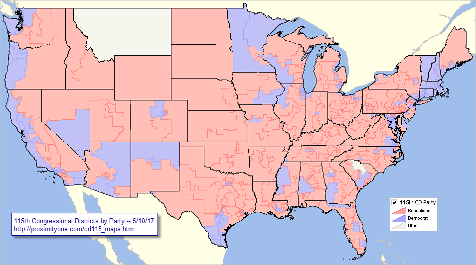
As of November 2019:
• the 19 districts with highest MHI have Democrat incumbents
• the 10 districts with the highest Gini Index have Democrat incumbents
• there are 69 Republican incumbent districts above the all districts MHI
• there are 149 Democrat incumbent districts above the all districts MHI
• the MHI of the 236 Democrat incumbent districts is $66,829
• the MHI of the 199 Republican incumbent districts is $56,505
Median household income is only one measure of economic prosperity.
See more at http://proximityone.com/cd.htm.

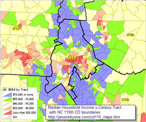
Patterns of Economic Prosperity 116th Congressional District
The following graphic shows patterns of 2018 median household income by 116th Congressional District. Use GIS tools/data to generate similar views for any state and/or drill-down. Click graphic for larger view with more detail. Expand browser window for best quality view.

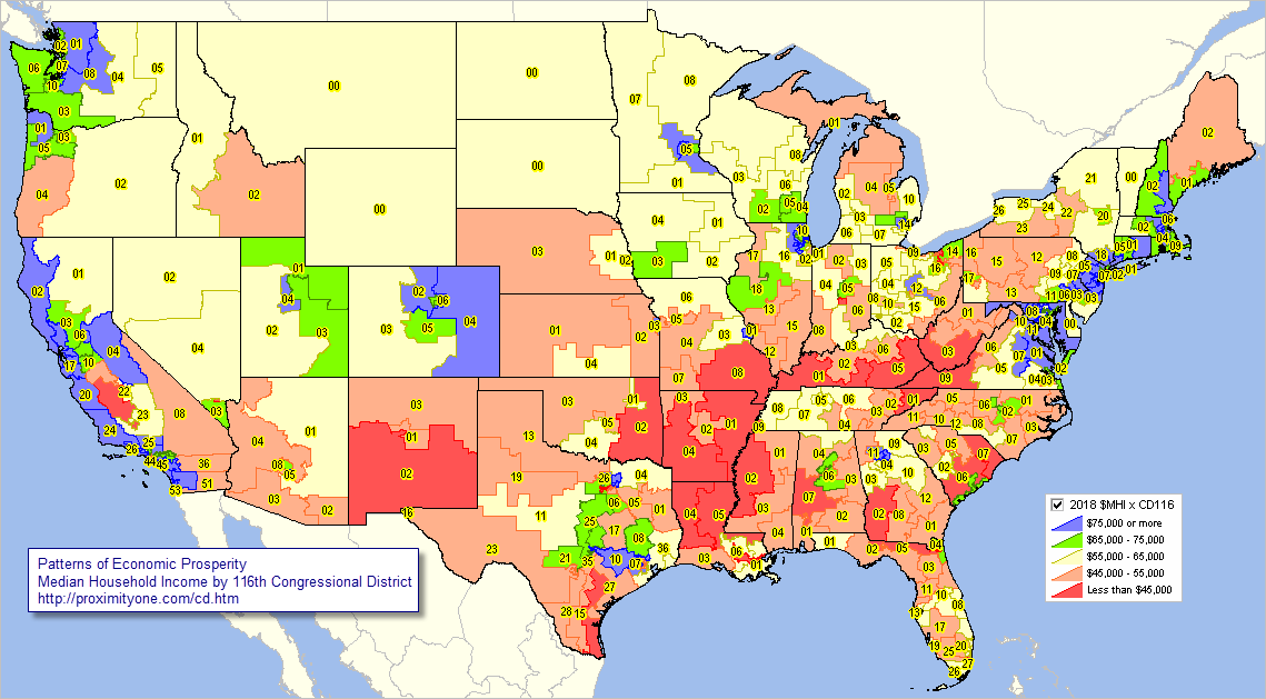
– view developed using ProximityOne CV XE GIS and related GIS project.

Using the Interactive Table
— view, rank, compare districts based on your criteria.
— example,which districts have the highest median household income?
Use the interactive table to examine incumbency and and demographic characteristics of the 116th Congressional Districts (CDs). The following view illustrates use of the table. This view shows use a query to show the ten CDs having highest 2018 median household income.

Try using the interactive table to existing districts and categories of interest.

Congressional District/State Legislative District Group
Join in .. be a part of the Congressional Districts/State Legislative District (CDSLD) group. Access analytical tools and data. Learn about CDSLD analytics, patterns and trends. Share insights with like-minded stakeholders.

Demographic-Economic Analytics Web Sessions
Join me in a Demographics Analytics Lab session to discuss more details about accessing and using wide-ranging demographic-economic data and data analytics. Learn more about using these data for areas and applications of interest.

About the Author
— Warren Glimpse is former senior Census Bureau statistician responsible for innovative data access and use operations. He is also the former associate director of the U.S. Office of Federal Statistical Policy and Standards for data access and use. He has more than 20 years of experience in the private sector developing data resources and tools for integration and analysis of geographic, demographic, economic and business data. Contact Warren. Join Warren on LinkedIn.

U.S. House of Representatives 2020 Apportionment

.. Congressional Apportionment by State .. 2010 & projected 2020 state by state congressional seats.

What will the results of Census 2020 tell us us about how the House of Representatives will be reapportioned, state by state? This section examines scenarios which might occur based on state population projections. See related Web section http://proximityone.com/apportionment.htm for more detail and interactive table.

Use the GIS tools and project to make your own map views … see details
.. use in classroom .. research .. reference .. collaboration.

This section has been developed using
– 2020 apportionment population projections
.. part of the ProximityOne Situation & Outlook (S&O)
– the reapportionment/redistricting feature of the CV XE GIS software
The 2020 population projections reflect anticipated change under one scenario. Those values are then used in the CV XE GIS reapportionment operation to compute the number of House seats shown in the related table.

Apportionment of the U.S. House of Representatives
— based on the 2010 Census

– view created with CV XE GIS. Click graphic for larger view with more detail.

Apportionment of the U.S. House of Representatives
— based on ProximityOne 2020 Population Projections

– view created with CV XE GIS. Click graphic for larger view with more detail.

Congressional apportionment is the process of dividing the 435 memberships, or seats, in the House of Representatives among the 50 states based on the population figures collected during the decennial census. The number of seats in the House has grown with the country. Congress sets the number in law and increased the number to 435 in 1913. The Constitution set the number of representatives at 65 from 1787 until the first Census of 1790, when it was increased to 105 members. More about apportionment.

Initial Census 2020 demographic data, the apportionment data, will be released by December 31, 2020. See related Census 2010 Apportionments.

Apportionment totals were calculated by a congressionally defined formula, in accordance with Title 2 of the U.S. Code, to divide among the states the 435 seats in the U.S. House of Representatives. The apportionment population consists of the resident population of the 50 states, plus the overseas military and federal civilian employees and their dependents living with them who could be allocated to a state. Each member of the House represents, on average, about 710,767 people for Census 2010.

Using the Interactive table
The following graphic illustrates use of the 2010 & 2020 apportionment by state and historical apportionment 1910 to 2010. Sort on any column; compare apportionment patterns over time. Click graphic for larger view.
Use the interactive table at http://proximityone.com/apportionment.htm#table.

Congressional District/State Legislative District Group
Join the CDSLD Group (http://proximityone.com/cdsld.htm), a forum intended for individuals interested in accessing and using geodemographic data and analytical tools relating to voting districts, congressional districts & state legislative districts and related geography with drill-down to intersection/street segment and census block level. Receive updates on topics like that of this section.

Data Analytics Web Sessions
Join me in a Data Analytics Lab session to discuss more details about accessing and using wide-ranging demographic-economic data and data analytics. Learn more about using these data for areas and applications of interest.

About the Author
— Warren Glimpse is former senior Census Bureau statistician responsible for innovative data access and use operations. He is also the former associate director of the U.S. Office of Federal Statistical Policy and Standards for data access and use. He has more than 20 years of experience in the private sector developing data resources and tools for integration and analysis of geographic, demographic, economic and business data. Contact Warren. Join Warren on LinkedIn.

Making & Using Custom 115th Congressional District Maps

.. using GIS resources to create custom 115th Congressional District maps .. use the methods, data and tools described in this section to develop custom congressional district maps. View patterns of economic prosperity by neighborhood for one or all congressional districts. Flexibly associate a congressional district boundary with related geography and subject matter.  See related Web section for more details.

Join the Congressional District-State Legislative District (CDSLD) Group .. be a part of the community. .. click here to join .. there is no cost.

Coming up … mapping/analyzing school district finances in context of the 115th Congressional Districts (June 2017).

See the related section on Making/Using 113th Congressional District Maps.
.. view different congressional district vintages in same map.

115th Congressional Districts by Incumbent Party Affiliation
This view and related GIS project/data update when changes are made to the 115th Congressional Districts incumbents (last updated 5/10/17). Party affiliation shown in this view is also available in the related interactive table. Click graphic for larger view. Expand browser window for best quality view.

– View developed using CV XE GIS and related GIS project.
– see below in this section about using this GIS project.

Use the Geographic Information System (GIS) tools and data to view/show congressional district in context with roads, landmarks and other geography. Flexibly add labels. Create pattern views. Add your own data.

Patterns of Economic Prosperity by 115th Congressional District
The following graphic shows patterns of ACS 2015 median household income (MHI) by 115th Congressional District. Click graphic for larger view. Expand browser window for best quality view.

– View developed using CV XE GIS and related GIS project.
– use the GIS project and tools see below to create different views.

Examine Characteristics of any Congressional District
The following graphic shows patterns of ACS 2015 median household income (MHI) by census tract in context of 115th Congressional Districts in a region of North Carolina. CD 3712 (Charlotte area) is shown with bold boundary. It is easy to see which areas/tracts have different levels of economic prosperity.

– View developed using CV XE GIS and related GIS project.
– use the GIS project and tools see below to create different views; add other layers.

Creating congressional district maps is often specific to a particular analysis, zoom-view, labeling, combination of different geographies or other considerations. While there are no estimates of unemployment by congressional district, using GIS tools it is possible to view/geospatially analyze patterns of unemployment within congressional district by county, census tract, block group and other geography.

Join me in a Data Analytics Lab session to discuss more details about accessing and using wide-ranging demographic-economic data and data analytics. Learn more about using these data for areas and applications of interest.

About the Author
— Warren Glimpse is former senior Census Bureau statistician responsible for innovative data access and use operations. He is also the former associate director of the U.S. Office of Federal Statistical Policy and Standards for data access and use. He has more than 20 years of experience in the private sector developing data resources and tools for integration and analysis of geographic, demographic, economic and business data. Contact Warren. Join Warren on LinkedIn.

115th Congressional Districts: Analysis and Insights

.. interpretative data analytics; tools, data & methods ..  this section is focused on 115th Congressional District geographic, demographic and economic patterns and characteristics. Use tools and data reviewed here to examine/analyze characteristics of one congressional district (CD) or a group of CDs based on state, party or other attribute. Use the GIS resources described here for general CD reference/pattern/analytical views, to examine current demographics and demographic change and for redistricting applications. See this related Web section for more details.

Examining the 115th Congressional Districts
• the 115th Congress runs from January 2017 through December 2018.
• FL, MN, NC, VA have redistricted since the 114th CD vintage;
  .. some 115th CDs have new boundaries compared the 114th CDs.
• view, rank, compare CDs using the interactive table.
  .. table uses ACS 2015 data for 115th CDs & include incumbent attributes.
  .. examine districts by party affiliation.
• use these more detailed 114th CD interactive tables
  .. data based on 2015 American Community Survey – ACS 2015.
  .. corresponding data for the 115th CDs from ACS 2016 available Sept 2017.
• use the new GIS project including 114th & 115th CDs described below.
  .. create CD thematic and reference maps;
  .. examine CDs in context of other geography & subject matter.
• join us in the April 25 Data Analytics Lab session

Visual Analysis of Congressional Districts
The following views 1) provide insights into patterns among the 115th CDs and 2) illustrate how 114th to 115th geographic change can be examined. Use CV XE GIS software with the GIS project to create and examine alternative views.

Patterns of Household Income by 115th Congressional District
The following graphic shows the patterns of the median household income by 115th Congressional District based on the American Community Survey 2015 1-year estimates (ACS2015). The legend in the lower left shows data intervals and color/pattern assignment

.. view developed with ProximityOne CV XE GIS and related GIS project.

Charlotte NC-SC Metro Area
  – with 114th/115th Congressional District 12

The following graphic shows North Carolina CD 12 with 114th boundary (blue) and 115th boundary (pale yellow) and Charlotte metro bold brown boundary. Click graphic for larger view with more detail. Expand browser window for best view.

.. view developed using the CVGIS software.

• View zoom-in to Charlotte city & Mecklenburg County.

115th Congressional District Interactive Table
Use the interactive table to examine characteristics of one congressional district (CD) or a group of CDs. The following graphic illustrates use of the interactive table. First, the party type was selected, Democratic incumbents in this example. Next, the income and educational attainment columns were selected. Third, the set of districts were sorted on median household income. It is quick and easy to determine that CA18 has the highest median household income and that the MHI is $1,139,900. Try using the table to examine districts of interest.

Join me in a Data Analytics Lab session to discuss more details about accessing and using wide-ranging demographic-economic data and data analytics. Learn more about using these data for areas and applications of interest.

About the Author
— Warren Glimpse is former senior Census Bureau statistician responsible for innovative data access and use operations. He is also the former associate director of the U.S. Office of Federal Statistical Policy and Standards for data access and use. He has more than 20 years of experience in the private sector developing data resources and tools for integration and analysis of geographic, demographic, economic and business data. Contact Warren. Join Warren on LinkedIn.