Examining the Situation & Outlook

.. this blog focuses on topics regarding the current situation and outlook .. what is happening now, historical trends and into the future .. demographic and economic characteristics for wide-ranging types of geography .. what will change where, when, by how much .. and how change might it impact you .. data resources and tools enabling a deeper dive; relating to decision-making and management. Access, analyze data with only a browser using VDA Web GIS. Get email updates with new posts as they happen … click Follow button at right.

How & Why County Population is Changing

… did you know? Of the total 3,144 counties in the United States, 48 have more than 1 million residents as of 2023. Learn which counties, where they are and how/why they are changing. Use tools and methods described in this section to learn about how and why your counties of interest are changing. This is one of a series on the topic of county population dynamics. Click the Follow button to receive update notices.

Largest, Fast Growing Counties
The following graphic shows the largest 10 counties, experiencing 3% or more growth from 2020 to 2023, based on the latest official population estimates. Counties are ranked based on the population percent change 2020 to 2023. Collin County, TX, in the Dallas metro, leads the group with an 11.3% gain. You can create similar but different views/analytics using the OVDAW online tool described below. Click graphic for larger view.

Why these Data are Important
These data are official Federal county statistics. They are used by the Federal, state and local governments in a wide range of application areas. These data are used by Federal agencies to analyze, administer programs, develop other data. The Bureau of Economic Analysis will use these data to produce Personal Income by County and Metropolitan Area, 2023 (November) and Real Personal Consumption Expenditures by State and Real Personal Income by State and Metropolitan Area, 2023 (December), among others. They are used within the Census Bureau as controls for statistical survey estimates. They are the population county components used to develop corresponding CBSA/metro data. They are used as measure of how, why and by how much county population is changing. They provide insights into, for example, where a business might open a new business based in part on changing population. The components of population change tell us yet other things .. reviewed in upcoming blogs.

Start Using Open VDA Web GIS (OVDAW)
Nothing to install, no registration, no fee.
Start creating maps and analyzing data.
  • Click here to Start Open VDA Web GIS
  • Click here to Learn More About Using OVDAW

More About Population & Components of Change
These “population and components of change” annual data 2020 through 2023 are an annually updated time series enabling stakeholders to examine trends and perform wide-ranging analyses. The 2020-2023 data are model-based estimates developed by the Census Bureau. ProximityOne uses these and related data to develop projections annually through 2060.
Components of change include births, deaths and migration. Estimates and projections are developed using the population identity:
P[t] = P[t-1] + B[t,t-1] + D[t,t-1] + M[t,t-1]
Population for the year t are determined by adding the population last year to births (B), subtracting deaths (D) and adding net migration (M) during the year. The components are determined using separate equations in the model.

About VDA GIS
Use VDA GIS tools to meet wide-ranging mapping needs and geospatial analysis. VDA Desktop GIS and VDA Web GIS have similar features that can be used separately or together. Each is a decision-making information resource designed to help stakeholders create and apply insight. VDA Web GIS is access/used with only a Web browser; nothing to install; GIS experience not required. VDA Desktop GIS is installed on a Windows computer and provides a broader range of capabilities compared to VDA Web GIS. VDA GIS resources have been developed and are maintained by Warren Glimpse, ProximityOne (Alexandria, VA) and Takashi Hamilton, Tsukasa Consulting (Osaka, Japan).

Data Analytics Web Sessions
Join us in the every Tuesday, Thursday Data Analytics Web Sessions. See how you can use VDA Web GIS and access different subject matter for related geography. Get your geographic, demographic, data access & use questions answered. Discuss applications with others.

About the Author
Warren Glimpse is former senior Census Bureau statistician responsible for national scope statistical programs and innovative data access and use operations. He is also the former associate director of the U.S. Office of Federal Statistical Policy and Standards for data access and use. He has more than 20 years of experience in the private sector developing data resources and tools for integration and analysis of geographic, demographic, economic and business data. Join Warren on LinkedIn.

Examining Congressional Districts using VDA Desktop GIS via RDS

.. this section builds on the previous section “Using VDA Desktop GIS with Remote Desktop“. To recap, that section summarized how to make reference and geostatistical maps using the VDA Desktop GIS online via our Remote Desktop Service. Perform simple, easy-to-use mapping tasks, or more advanced geospatial analyses using VDA, Visual Data Analytics, GIS .. Geographic Information Systems. Here I review how to use any VDA GIS project with only Internet and most any device.

An Example using the California CD 06 (CD0646) GIS Project
1. Start VDA Desktop GIS using Remote Desktop Service .. see details.
2. When the RDS screen appears, click the VDAGIS icon, starting VDAD/RDS
.. this shows the default view, the “Base” GIS project.
3. Use File>Open to open the CD0646 GIS project
.. Next, the user could open any available GIS project.
.. Click File>Open then select file c:\cvxe\cd0646\cd0646.gis .. the project opens
.. Congressional District California 46
.. located in the Anaheim – Santa Ana area of Orange County, CA
4. Reviewing the Start-up View
The following graphic shows, the project start-up view
.. California CD 46 (bold boundary) and Congressional Communities
.. examining economic prosperity (median household income) by census tract</a.

CA CD 46 with CCs; Patterns of Economic Prosperity .. click for larger view

Drill-down View of Santa Ana area by Ward .. click for larger view
This zoom-in view shows Santa Ana wards as with red boundaries in context of other geography reviewed above.

See Santa Ana ward boundaries using the official Santa Ana City website.

Citizen Voting Age Population by Block Group .. click for larger view
The following zoom-in view shows patterns of Citizen Voting Age Population (CVAP) by block group (BG) in the Santa Ana area in context of Congressional Community 0646005 (bold black boundary). Label shows total CVAP in that BG.

Drill-down View to Ward-CC-Block .. click for larger view
This zoom-in view shows one Santa Ana ward (red boundary) in context of census blocks (black boundaries) and related Congressional Community (gray bold boundary). Congressional Communities (CC) are geographic areas that nest within a Congressional District (CD), fully and exactly exhausting that CD area. CCs are comprised of a set of contiguous census blocks based on a range of criteria.

What’s Ahead
Updates on using VDA Desktop GIS will be included in forthcoming Blogs.
Don’t miss out! Click Follow in button at upper right.

About VDA GIS
Use VDA GIS tools to meet wide-ranging mapping needs and geospatial analysis. VDA Desktop GIS and VDA Web GIS have similar features that can be used separately or together. Each is a decision-making information resource designed to help stakeholders create and apply insight. VDA Web GIS is access/used with only a Web browser; nothing to install; GIS experience not required. VDA Desktop GIS is installed on a Windows computer and provides a broader range of capabilities compared to VDA Web GIS. VDA GIS resources have been developed and are maintained by Warren Glimpse, ProximityOne (Alexandria, VA) and Takashi Hamilton, Tsukasa Consulting (Osaka, Japan).

Data Analytics Web Sessions
Join us in the every Tuesday, Thursday Data Analytics Web Sessions. See how you can use VDA Web GIS and access different subject matter for related geography. Get your geographic, demographic, data access & use questions answered. Discuss applications with others.

About the Author
Warren Glimpse is former senior Census Bureau statistician responsible for national scope statistical programs and innovative data access and use operations. He is also the former associate director of the U.S. Office of Federal Statistical Policy and Standards for data access and use. He has more than 20 years of experience in the private sector developing data resources and tools for integration and analysis of geographic, demographic, economic and business data. Join Warren on LinkedIn.

Finding & Viewing a Census Tract

.. this section reviews how you can locate a census tract, neighborhood area, for an address or location. Do this with Open VDA Web GIS (OVDAW) with only a browser and Internet connection. No registration, no login, nothing to install. Start OVDAW .. an interactive map appears in a new window. There is no warranty for any aspect of this or related sections. The user is solely responsible for any use made of this or related sections, tools, data.

After the map view shows, enter a ZIP code, location or address in the Search bar and press enter.
.. to illustrate, enter 85258 (a ZIP code in Scottsdale, AZ) and press enter.
A zoom-in then shows a blue triangle marker at the location.
.. in the legend panel at left, click checkbox on for each of these layers:
– ZIP Codes Label (displays ZIP Code area labels/codes in map)
– ZIP Codes (displays ZIP Code area red boundaries in map)
– Tracts Label (displays Tract code and black tract boundaries in map)
.. navigate to preferred view (e.g., pan or zoom in/out)
.. use a screen capture tool to capture view meeting application objective

Pointer in graphic shows ZIP code 85258 with several tracts intersecting the 85258 ZIP code red boundary.

Or .. skip the settings and simply click the marker.
.. the tract area shows as cross-hatched.
.. the tract code and demographic profile shows in lower left panel.
.. optionally click the HTML button below profile panel to view profile as HMTL table.

ZIP Code- Census Tract Equivalence Table
Use this interactive table to view what census tracts intersect with a ZIP code or what ZIP codes intersect with a census tract. Use buttons below the table.

Updates on using VDAGIS with ZIP code and census tract data will be included in forthcoming Blogs. Don’t miss out! Click Follow in button at upper right.

About VDA GIS
Use VDA GIS tools to meet wide-ranging mapping needs and geospatial analysis. VDA Desktop GIS and VDA Web GIS have similar features that can be used separately or together. Each is a decision-making information resource designed to help stakeholders create and apply insight. VDA Web GIS is access/used with only a Web browser; nothing to install; GIS experience not required. VDA Desktop GIS is installed on a Windows computer and provides a broader range of capabilities compared to VDA Web GIS. VDA GIS resources have been developed and are maintained by Warren Glimpse, ProximityOne (Alexandria, VA) and Takashi Hamilton, Tsukasa Consulting (Osaka, Japan).

Data Analytics Web Sessions
Join us in the every Tuesday, Thursday Data Analytics Web Sessions. See how you can use VDA Web GIS and access different subject matter for related geography. Get your geographic, demographic, data access & use questions answered. Discuss applications with others.

About the Author
Warren Glimpse is former senior Census Bureau statistician responsible for national scope statistical programs and innovative data access and use operations. He is also the former associate director of the U.S. Office of Federal Statistical Policy and Standards for data access and use. He has more than 20 years of experience in the private sector developing data resources and tools for integration and analysis of geographic, demographic, economic and business data. Join Warren on LinkedIn.

Using VDA Desktop GIS with Remote Desktop

.. make reference and geostatistical maps using the VDA Desktop GIS online via our Remote Desktop Service. Perform simple, easy-to-use mapping tasks, or more advanced geospatial analyses. VDA .. Visual Data Analytics. GIS .. Geographic Information Systems. Here I review how to do this with only Internet and most any device. VDA Desktop GIS and associated “Base” project provides access to the Federal Statistical System and much more.

New York Congressional District 08 by Congressional Community .. an example
.. CD NY08 with CCs labeled with %Majority Minority .. click for larger view

How to use Remote Desktop Service Remote Desktop was envisioned as a protocol to connect a user’s desktop/device via Internet to a remote computer so that the user could access, run, use their files on the remote computer. Remote Desktop Service (RDS) provides far greater capabilities. In our case, we have installed VDA Desktop GIS (VDAD) on the Server enabling a user to run VDAD as if it were operating on the user’s computer. This enables a user to run VDAD 1) without installing anything and 2) using VDAD, a Windows-based program, on Macs, iOS and other devices.

Using VDAD with Remote Desktop Service
Start Remote Desktop Service. If this is the first time used, after starting RDS click the Add PC on the RDS interface, then key in the Server IP address .. 50.62.180.232. Next click the Server graphic. Next login using your userid and password. If needed, register here to get your userid and password. No fee. After logging in, click the VDAGIS icon to start VDAD.

VDAD Start-up View
Start up view shows counties; 48 contiguous states .. click for larger view

See more about using VDAD via RDS

Updates on using VDA Desktop GIS will be included in forthcoming Blogs.
Don’t miss out! Click Follow in button at upper right.

About VDA GIS
Use VDA GIS tools to meet wide-ranging mapping needs and geospatial analysis. VDA Desktop GIS and VDA Web GIS have similar features that can be used separately or together. Each is a decision-making information resource designed to help stakeholders create and apply insight. VDA Web GIS is access/used with only a Web browser; nothing to install; GIS experience not required. VDA Desktop GIS is installed on a Windows computer and provides a broader range of capabilities compared to VDA Web GIS. VDA GIS resources have been developed and are maintained by Warren Glimpse, ProximityOne (Alexandria, VA) and Takashi Hamilton, Tsukasa Consulting (Osaka, Japan).

Data Analytics Web Sessions
Join us in the every Tuesday, Thursday Data Analytics Web Sessions. See how you can use VDA Web GIS and access different subject matter for related geography. Get your geographic, demographic, data access & use questions answered. Discuss applications with others.

About the Author
Warren Glimpse is former senior Census Bureau statistician responsible for national scope statistical programs and innovative data access and use operations. He is also the former associate director of the U.S. Office of Federal Statistical Policy and Standards for data access and use. He has more than 20 years of experience in the private sector developing data resources and tools for integration and analysis of geographic, demographic, economic and business data. Join Warren on LinkedIn.

Congressional Districts & Congressional Community Web Sessions

.. did you know? .. 19 congressional districts have lost more than 4% population since 2020? Which ones? What is causing the loss? How is the loss distributed across the district? Will these trends continue? Which districts are growing? Based on the 2020 Census, the Diversity Index for the 118th Congressional Districts ranged from 12.5% (Kentucky 05) to 78.5% (Hawaii 02). What and why is the Diversity Index important? What are economic characteristics of districts? How can you have your voice better heard by Congress through a congressional communities? How can stakeholders easily relate diverse topics like school districts, K-12 education, urban/rural areas, low and moderate income by census tract, ZIP codes, state legilslative districts among others to congressional districts and congressional communities? Get answers here. Learn more about these topics in this session.

Join us in the every Wednesday Zoom web session
click here for 10/11/23 overview & connectivity details


Who Benefits?
 – strategists needing to understand demographic-economic change
 – policymakers and staff and stakeholders dealing with policy development
 – residents/constituents/participants in a congressional community
 – learners & researchers regarding CC, CD mapping & geodemographic topics

About Congressional Districts & Congressional Communities

Congressional Districts. The November 2022 elections determined the representatives for the 118th Congressional Districts (CDs) January 2023-December 2024 session. The 118th Congressional District boundaries reflect the redistricting process based on Census 2020 results.

Congressional Communities. Congressional Communities (CC) are a concept and development of Congressional Communities, a non-profit organization. CCs have been developed to better enable constituents to have their voice heard by policymakers and vice versa. The approximate 7,400 CCs cover the U.S. wall-to-wall developed by the CC team and typically range from 30,000 to 70,000 population. CCs have been developed based on several criteria and are not arbitrary subdivisions of CDs. There are a set of CCs that nest exactly within each CD. Demographic data have been developed for each CC based on Census 2020 census block data by the CC team.

CC stakeholders may map and geospatially analyze their CCs and CDs.
CC organizations are comprised of residents of their respective CCs.
join in to a CC here .. illustrative details for a CC

Four Topics in this Web Session
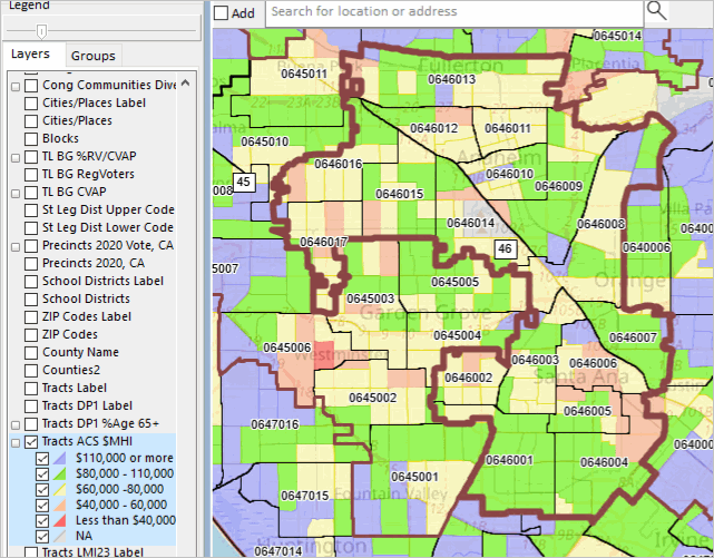
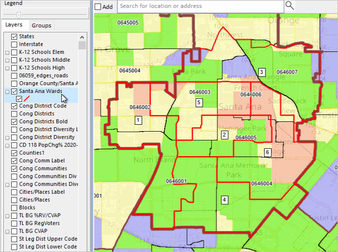
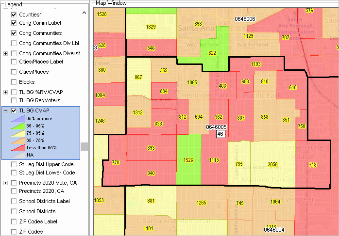
.. illustrative applications are focused on California CD 47.
.. Use your own CD/region of interest.
.. ~30 minute presentation followed by discussion.

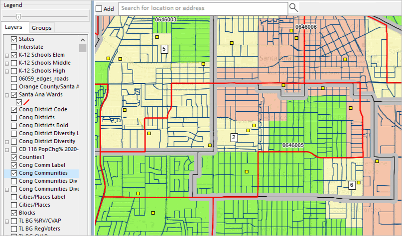
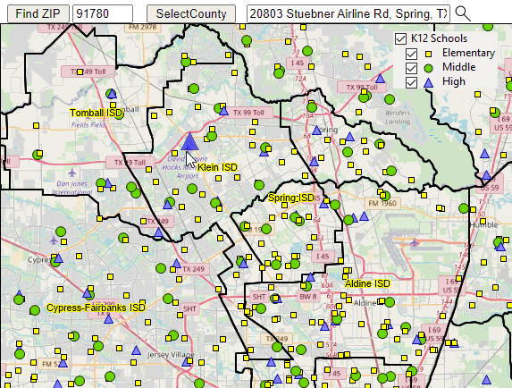
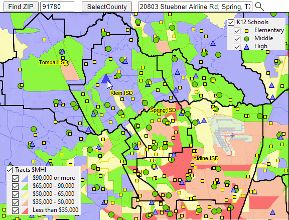
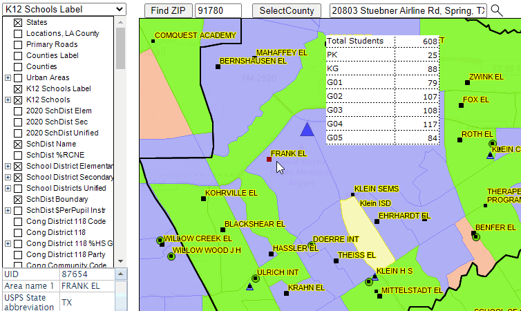
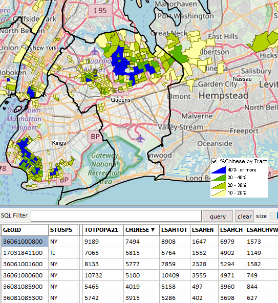
1. CD/CC Visualization using the Open VDA Web GIS
.. click here to start Open VDA Web GIS (OVDAW) .. all you need is a browser
.. step-by-step example .. optionally follow-along

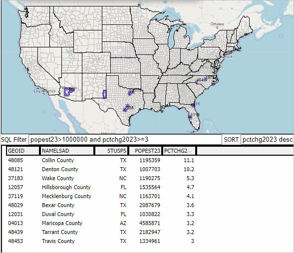
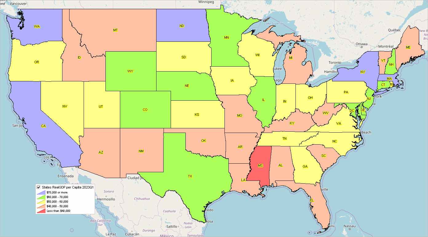
Patterns of %Population Change 2020-2022 by 118th Congressional District

.. learn how to develop variations of this view.

2. 118th Congressional Districts & 2020-2022 Demographics
.. Congressional Districts Main
.. using the CD Census 2020 & ACS 2022 interactive table

In August 2023, the Census Bureau released the first Census 2020 demographics for the 118th Congressional Districts. In September 2023, the Census Bureau released the American Community Survey 2022 1-year estimates (ACS2022) for the 118th Congressional Districts. These data provide reasonably current data on a myriad of socioeconomic data. The Census Bureau also maintains the official national scope boundary files (for mapping and geospatial analysis) for the 118th Congressional Districts.
The Census Bureau also develops the County Business Patterns data for the 118th Congressional Districts. Learn more about the scope of these data and how they can be accessed and used. Aside from these data resources, the Federal statistical system (FSS) produces very little data for congressional districts.

What can I learn? Scope of annual ACS-based subject matter.
General Demographics .. Social Characteristics .. Economic Characteristics .. Housing Characteristics

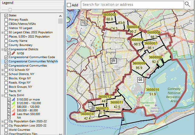
3. 118th Congressional District & Congressional Community Diversity
.. Congressional Districts Diversity
.. using the CD & CC interactive table

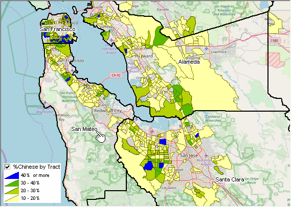
Patterns of Diversity by Congressional Community .. CA CD 47

  .. learn how to develop variations of this view.


4. Comparative GeoDemographic Narrative Profiles

.. using Demographic Analytics (DA) tool to compare CDs, CCs, and other areas
.. Census 2020 “DHC” detailed data released 8/31/23
.. accessing the new Census 2020 DHC-based “Demographic Profile 1” (DP1)
.. examples — running DA
– CA CC 0647001 compared to CA CD 47 Tabular Report
– CA CC 0647001 compared to CA CD 47 Narrative Profile
.. creating tabular report and narrative profile for areas of interest.
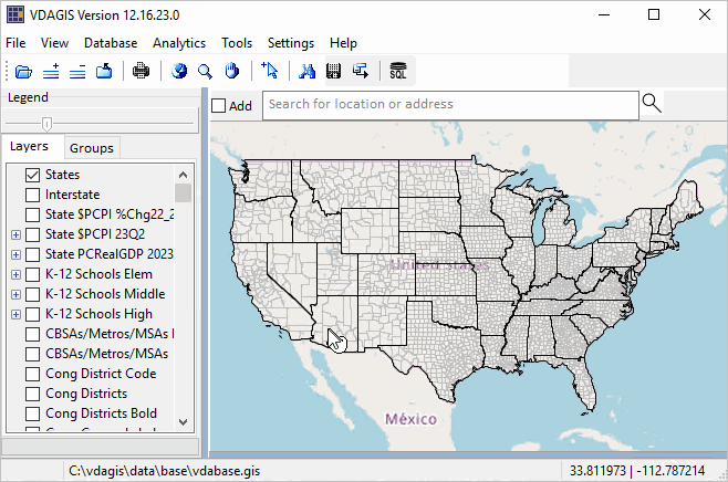
About VDA GIS
Use VDA GIS tools to meet wide-ranging mapping needs and geospatial analysis. VDA Desktop GIS and VDA Web GIS have similar features that can be used separately or together. Each is a decision-making information resource designed to help stakeholders create and apply insight. VDA Web GIS is access/used with only a Web browser; nothing to install; GIS experience not required. VDA Desktop GIS is installed on a Windows computer and provides a broader range of capabilities compared to VDA Web GIS. VDA GIS resources have been developed and are maintained by Warren Glimpse, ProximityOne (Alexandria, VA) and Takashi Hamilton, Tsukasa Consulting (Osaka, Japan).

Data Analytics Web Sessions
Join us in the every Tuesday, Thursday Data Analytics Web Sessions. See how you can use VDA Web GIS and access different subject matter for related geography. Get your geographic, demographic, data access & use questions answered. Discuss applications with others.

About the Author
Warren Glimpse is former senior Census Bureau statistician responsible for national scope statistical programs and innovative data access and use operations. He is also the former associate director of the U.S. Office of Federal Statistical Policy and Standards for data access and use. He has more than 20 years of experience in the private sector developing data resources and tools for integration and analysis of geographic, demographic, economic and business data. Join Warren on LinkedIn.

State Economic Trends

.. examining state quarterly GDP trends, 2023 update .. the BEA state quarterly Gross Domestic Product (about GDP) estimates are among the more important regional economic time series. These estimates provide a comprehensive measure of the state level economy and have only a 3-month lag between reference data and data of availability.

California had the highest real GDP among all states over the year 2022Q1-2023Q1. Texas follows close behind and experienced the highest rate of growth in real GDP among all states over the same period. Two states experienced a decline in real GDP over the year. How will state and regional GDP components change over the next five years? What policy actions might affect this and how, when? Learn more in the next blog update on predicting outcomes using statistical models.

Examining Patterns of 2023Q1 per Capita Real GDP by State
Use the “no login” version of VDA Web GIS to examine patterns of 2023Q1 per capita real GDP by state as illustrated in the following graphic. Nothing to install. Start VDA Web Base here. See more about VDA Web Base. Click graphic for larger view.

How State GDP is Changing
Use this interactive table to learn more about how state GDP is changing. View, sort, examine GDP time series attributes: real GDP, real GDP indexes, current GDP. State GDP matters as it tells us about how the aggregate economy is changing by region. But stakeholders need more than just recent data. More needs to be known about the current situation, how things might change and how change might impact demographic-economic outcomes in the future.

About VDA GIS
Use VDA GIS tools to meet wide-ranging mapping needs and geospatial analysis. VDA Desktop GIS and VDA Web GIS have similar features that can be used separately or together. Each is a decision-making information resource designed to help stakeholders create and apply insight. VDA Web GIS is access/used with only a Web browser; nothing to install; GIS experience not required. VDA Desktop GIS is installed on a Windows computer and provides a broader range of capabilities compared to VDA Web GIS. VDA GIS resources have been developed and are maintained by Warren Glimpse, ProximityOne (Alexandria, VA) and Takashi Hamilton, Tsukasa Consulting (Osaka, Japan).

Data Analytics Web Sessions
Join us in the every Tuesday, Thursday Data Analytics Web Sessions. See how you can use VDA Web GIS and access different subject matter for related geography. Get your geographic, demographic, data access & use questions answered. Discuss applications with others.

About the Author
Warren Glimpse is former senior Census Bureau statistician responsible for national scope statistical programs and innovative data access and use operations. He is also the former associate director of the U.S. Office of Federal Statistical Policy and Standards for data access and use. He has more than 20 years of experience in the private sector developing data resources and tools for integration and analysis of geographic, demographic, economic and business data. Join Warren on LinkedIn.

New 2023 Metropolitan Area Delineations

.. new 2023 CBSA/metro delineations have just been released. See more about the 2023 delineations. Core-Based Statistical Areas (CBSAs) are officially designated by the U.S. Office of Management and Budget (OMB). CBSAs are composed of one or more contiguous counties and must meet a population size criteria of associated Urban Area(s). CBSAs are classified as the larger Metropolitan Statistical Areas (MSAs; 387 in United States and 6 in Puerto Rico) and smaller Micropolitan Statistical Areas (MISAs; 538 in United States and 4 in Puerto Rico). Use the interactive table to view, rank, query 2023 CBSAs by component area.

These changes can have a profound impact on matters including policy formulation, resource allocation, general research .. to name a few. If you have data by metro, and the geography of the metro changes over time, analytical results, trend implications, can be very misleading. But there’s more.

Two notable aspects about the new 2020 CBSA standards, used for the 2023 delineations, are that they 1) no longer make use of NECTAs (New England City and Town Areas) and 2) the qualifying core population is now based on the population size of the relevant Urban Area(s) rather than cities.

The Houston, TX Metro — an Illustrative Example
The Houston, TX metro (MSA) changed from 9 counties based on the 2020 CBSA delineations to 10 counties based on the 2023 delineations. As shown in the graphic below, San Jacinto County, TX was added. The bold orange boundary shows the 2023 delineations. The black bold boundary shows the 2020 delineations. Note that four counties contiguous to the Houston MSA became MSAs effective with the 2023 delineations. These counties were classified as MISAs before the 2023 delineation.

CBSA/Metro Mapping & GeoSpatial Analysis
View and examine the 2020 and 2023 vintage CBSAs using the VDA Web GIS with the MetroDynamics GIS project. Examine metros in context of other geography. Click here to start VDA Web GIS; uses a browser, nothing to install. Use the spreadsheet/grid feature to examine the metros in a tabular manner.

About VDA GIS
Use VDA GIS tools to meet wide-ranging mapping needs and geospatial analysis. VDA Desktop GIS and VDA Web GIS have similar features that can be used separately or together. Each is a decision-making information resource designed to help stakeholders create and apply insight. VDA Web GIS is access/used with only a Web browser; nothing to install; GIS experience not required. VDA Desktop GIS is installed on a Windows computer and provides a broader range of capabilities compared to VDA Web GIS. VDA GIS resources have been developed and are maintained by Warren Glimpse, ProximityOne (Alexandria, VA) and Takashi Hamilton, Tsukasa Consulting (Osaka, Japan).

Data Analytics Web Sessions
Join us in the every Tuesday, Thursday Data Analytics Web Sessions. See how you can use VDA Web GIS and access different subject matter for related geography. Get your geographic, demographic, data access & use questions answered. Discuss applications with others.

About the Author
Warren Glimpse is former senior Census Bureau statistician responsible for national scope statistical programs and innovative data access and use operations. He is also the former associate director of the U.S. Office of Federal Statistical Policy and Standards for data access and use. He has more than 20 years of experience in the private sector developing data resources and tools for integration and analysis of geographic, demographic, economic and business data. Join Warren on LinkedIn.

Hispanic Population by Specific Origin by ZIP Code

.. the U.S. Hispanic population increased by 24-percent from 2010 to 2021. This change reflects net Hispanic immigration plus Hispanic population who are otherwise residents. The following graphic shows how the U.S. national scope Hispanic population by specific origin changed from 2010 to 2021. Use this interactive table to learn about Hispanic population by specific origin by ZIP code. Click graphic for larger view.

How the Hispanic Population by Specific Origin is Changing

Examining Patterns of Percent Mexican Population by ZIP Code
The graphic below shows ZIP code areas with ZIP code as upper label and percent Mexican population as lower label in context of Fresno city, CA (orange cross-hatch pattern). VDA Desktop GIS users may create this view (or variations) for any area using the Mapping Statistical Data GIS project.

More About Hispanic Population
The U.S. Office of Management and Budget (OMB) defines “Hispanic or Latino” as a person of Mexican, Cuban, Puerto Rican, South or Central American, or other Spanish culture or origin regardless of race. People who identify with the terms “Hispanic” or “Latino” are those who classify themselves in one of the specific Hispanic or Latino categories listed on the decennial census of ACS questionnaire. Data tabulations. estimates, of the Hispanic population are “of any race” unless otherwise stated. See the section Hispanic Population by Specific Origin for more information.

About VDA GIS
Use VDA GIS tools to meet wide-ranging mapping needs and geospatial analysis. VDA Desktop GIS and VDA Web GIS have similar features that can be used separately or together. Each is a decision-making information resource designed to help stakeholders create and apply insight. VDA Web GIS is access/used with only a Web browser; nothing to install; GIS experience not required. VDA Desktop GIS is installed on a Windows computer and provides a broader range of capabilities compared to VDA Web GIS. VDA GIS resources have been developed and are maintained by Warren Glimpse, ProximityOne (Alexandria, VA) and Takashi Hamilton, Tsukasa Consulting (Osaka, Japan).

Data Analytics Web Sessions
Join us in the every Tuesday, Thursday Data Analytics Web Sessions. See how you can use VDA Web GIS and access different subject matter for related geography. Get your geographic, demographic, data access & use questions answered. Discuss applications with others.

About the Author
Warren Glimpse is former senior Census Bureau statistician responsible for national scope statistical programs and innovative data access and use operations. He is also the former associate director of the U.S. Office of Federal Statistical Policy and Standards for data access and use. He has more than 20 years of experience in the private sector developing data resources and tools for integration and analysis of geographic, demographic, economic and business data. Join Warren on LinkedIn.

Locating & Examining K-12 Schools Using Web GIS

.. the approximate 100,000 K-12 public schools can be examined using the Visual Data Analytics VDA Web GIS with the K-12 Schools & School Districts GIS project. This Web based resource is ready-to-use with only a Web browser, supports most devices and requires nothing to install. This section provides an introduction to this resource and how it can be used to locate schools of interest and examine them in context of other geography and subject matter — like economic prosperity.

K-12 Schools in Context of School Districts & Economic Prosperity
The following graphic shows the focus area for this blog. It shows K-12 public schools as markers in context of Klein ISD, TX school district (bold brown boundary) and patterns of economic prosperity by census tract. The search bar above the map contains an illustrative address to be located. The user would replace this address with their own address of interest using any address, anywhere. In this example, the location is shown by the larger blue triangle at the pointer.

Using VDA Web GIS with the K-12 Schools & School Districts Project
With any Web browser (desktop recommended, but any device), proceed as follows:
.. Click Start VDA Web GIS and sign-in
.. On the second page, optionally install VDA Desktop GIS (not necessary)
.. On the third page select the “K-12 Schools & School Districts” project
.. after the full map interface opens (5-10 seconds),
  – key in the address “20803 Stuebner Airline Rd, Spring, TX 77379” (no quotes)
      in search bar above map and press enter
.. in legend panel at left, click on the “K12 Schools” layer checkbox
.. zoom-out (button below map) until this view appears:

View with K-12 Schools Layer

Viewing Median Household Income by Census Tract
.. in legend panel at left, click on the “Tracts by $MHI” layer checkbox

Zoom-in Viewing Attributes of Selected Schools
.. in upper left dropdown, select active layer as “K-12 Schools”
.. zoom-in to view shown below
.. click on Frank ES marker to show a profile
.. partial example shown graphic (enrollment by grade)

About VDA GIS
There are two VDA GIS tools that have similar features that can be used separately or together. Each is a decision-making information resource designed to help stakeholders create and apply insight. VDA Web GIS is access/used with only a Web browser; nothing to install; GIS experience not required. VDA Desktop GIS is installed on a Windows computer and provides a broader range of capabilities compared to VDA Web GIS. VDA GIS resources have been developed and are maintained by Warren Glimpse, ProximityOne (Alexandria, VA) and Takashi Hamilton, Tsukasa Consulting (Osaka, Japan).

Data Analytics Web Sessions
Join us in the every Tuesday, Thursday Data Analytics Web Sessions. See how you can use VDA Web GIS and access different subject matter for related geography. Get your geographic, demographic, data access & use questions answered. Discuss applications with others.

About the Author
Warren Glimpse is former senior Census Bureau statistician responsible for national scope statistical programs and innovative data access and use operations. He is also the former associate director of the U.S. Office of Federal Statistical Policy and Standards for data access and use. He has more than 20 years of experience in the private sector developing data resources and tools for integration and analysis of geographic, demographic, economic and business data. Join Warren on LinkedIn.

Examining Chinese Demographics by Census Tract

.. the 2021 U.S. Chinese (except Taiwanese) resident population estimate was 4,103,036 of total U.S. population 331,893,745 (1.25%) based on the ACS 2021 1-year data — a small percentage. But when examined by census tract many areas have a relatively large Chinese population. The focus of this section is on tools and data to examine patterns and characteristics of the Chinese population by 2020 census tract. To facilitate these analyses, a new Mapping Statistical Data project (MSD 071123) has been developed and is available to CV XE GIS and VDA Desktop users. The project has been used to develop the map graphic shown below. Develop similar drill-down views for other regions using these tools/data. The GIS project enables examining other characteristics of the Chinese population by census tract. The Chinese population is one of several population groups that can be studied in this manner.

Patterns of Percent Chinese Population by Census Tract in the San Francisco Area
The following graphic shows a thematic map of the percent Chinese population by tract in the San Francisco area. See the inset legend showing colors representing percent intervals.

Patterns of Chinese Population by Census Tract in the New York City Area
Tracts with the largest Chinese population are mainly in New York City as shown in the graphic below. Using the VDA table feature the “Chinese” field is ranked in descending order. Tract 36-061-000080 has the largest Chinese population among all tracts, 7,494.

About VDA GIS
There are two VDA GIS tools that have similar features that can be used separately or together. Each is a decision-making information resource designed to help stakeholders create and apply insight. VDA Web GIS is access/used with only a Web browser; nothing to install; GIS experience not required. VDA Desktop GIS is installed on a Windows computer and provides a broader range of capabilities compared to VDA Web GIS. VDA GIS resources have been developed and are maintained by Warren Glimpse, ProximityOne (Alexandria, VA) and Takashi Hamilton, Tsukasa Consulting (Osaka, Japan).

Data Analytics Web Sessions
Join us in the every Tuesday, Thursday Data Analytics Web Sessions. See how you can use VDA Web GIS and access different subject matter for related geography. Get your geographic, demographic, data access & use questions answered. Discuss applications with others.

About the Author
Warren Glimpse is former senior Census Bureau statistician responsible for national scope statistical programs and innovative data access and use operations. He is also the former associate director of the U.S. Office of Federal Statistical Policy and Standards for data access and use. He has more than 20 years of experience in the private sector developing data resources and tools for integration and analysis of geographic, demographic, economic and business data. Join Warren on LinkedIn.