Tag Archives: Phoenix

New Authorized Monthly Residential Construction by City 

.. access/analyze monthly building permits data for any/all of 7,700 cities in a few minutes via a web browser. Building permits data, a leading economic indicator, are one of the few current indicators available at the city level to examine characteristics and trends. These data can provide insights into the type and value of housing that is being added. Use the VDA Web GIS to examine how the housing situation is changing for cities of interest.

The VDA Web GIS MetroDynamics city layer/dataset is updated with the most recent 6 months of the number of housing units by type and value. The current data provide monthly aggregated data for January 2022 through June 2022. The layer/dataset includes many other attributes (see details). Of the ~19,000 U.S. cities, ~7,700 issue monthly building permits and accessible via this resource.

Examining City Housing Characteristics & Trends
An example: cities in the Phoenix, AZ area labeled with the total building permits.

.. table under map view shows cities with largest number of building permits.
.. see steps to develop the above map and table.

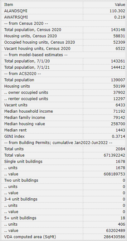
Illustrative Profile for Surprise, AZ
.. selected items from MetroDynamics City layer/dataset
.. integrated subject matter from several sources
.. building permits most current

About VDA Web GIS
VDA Web GIS is a decision-making information resource designed to help stakeholders create and apply insight. VDA Web GIS has been developed and is maintained by Warren Glimpse, ProximityOne (Alexandria, VA) and Takashi Hamilton, Tsukasa Consulting (Osaka, Japan).

About Building Permits Data
Building permits data are collected monthly by the Census Bureau from permit issuing agencies. Monthly data are reported for access within one month of the reporting date. Data are collected on the number of new housing units authorized by type of units in building by value.

About the Author
Warren Glimpse is former senior Census Bureau statistician responsible for national scope statistical programs and innovative data access and use operations. He is also the former associate director of the U.S. Office of Federal Statistical Policy and Standards for data access and use. He has more than 20 years of experience in the private sector developing data resources and tools for integration and analysis of geographic, demographic, economic and business data. Join Warren on LinkedIn.

Relating ZIP Codes and Census Tracts

.. what census tracts intersect with a ZIP code of interest? There are many reasons for the underlying the need to convert/equivalence ZIP codes to/from census tracts. Some organizations have to provide census tract codes for addresses/ZIP codes of clients to be in compliance with a law or regulation. Some organizations have addresses/ZIP codes of clients/locations for which they would like to determine the corresponding census tract codes to analyze census tract demographics. This post reviews tools and options for these operations. See related Web section to access interactive table and learn more about mapping and geospatially relating these two geographies.

Phoenix/Scottsdale, AZ ZIP Code-Census Tract Relationship
The following graphic illustrates the relationship between ZIP code area 85258 (orange fill pattern) with census tracts (green boundaries and geocode labels).
(StCtyTract=04013216813).
.. view created with ProximityOne CV XE GIS software and related GIS project.

Create your own maps of areas relating ZIP codes and census tract, in context of other geography. Use the CV XE GIS with shapefiles.

Using the Interactive Table
Use the ZIP code to census tract interactive table (opens new page) to answer questions such as:
• Which census tracts intersect with a ZIP code of interest?
• Which ZIP code(s) intersect with census tract(s) of interest?
• What is the Census 2010 population for a census tract and ZIP code combination?

The interactive equivalence/look-up table shows a row for each unique combination of a Census 2010 ZIP code area and Census 2010 census tract. The start-up view is sorted on the State-County-Tract column (StCtyTract). View ZIP codes in one state using the State selection button. To locate a ZIP code of interest, either use the Find ZIP query or sort on the ZIP code column and then scroll down the table until the ZIP of interest is located.

Example. Click Find ZIP button using the interactive table (opens new page) to view only the tracts intersecting with ZIP code 85258 (as shown in map view above). The Location 1 marker (see pointer in map) is located in the area intersecting ZIP code 85258 and census tract 2168.13. The refreshed table view is shown by the graphic below. There are nine tracts intersecting with this ZIP code; see the tract codes in the table.

Try this for a ZIP of interest:
• View the interactive table (opens new page).
• Click the Showall button below table.
• Key in your 5-digit ZIP code in edit box where 85258 now shows.
• Click Find ZIP button.
• Table refreshes showing only tracts intersecting with this ZIP code.

Scope of Tracts and ZIPs in Table
There are 150,806 rows in the table, each showing a unique combination of a census tract (73,057 Census 2010 tracts) and ZIP code area (33,120 Census 2010 ZCTAs). Each row represents an intersection of the specified census tract and ZIP code area and corresponds to a geographic area of one census block or more. The total population and housing units values have been derived by summing component census block values. The sum of the population column is 308,745,538, the United States Census 2010 total population.

Situation & Outlook Weekly Web Sessions
Join me in a Situation & Outlook web session to discuss more details about demographic-economic estimates and projections.

About the Author
— Warren Glimpse is former senior Census Bureau statistician responsible for innovative data access and use operations. He is also the former associate director of the U.S. Office of Federal Statistical Policy and Standards for data access and use. He has more than 20 years of experience in the private sector developing data resources and tools for integration and analysis of geographic, demographic, economic and business data. Contact Warren. Join Warren on LinkedIn.

Examining K-12 Public School Characteristics; 2015 National Update

.. resources to analyze k-12 school characteristics and patterns … the U.S. national scope 2012-13 K-12 public schools dataset has just been updated (annual update). Wide-ranging characteristics of each school are now available for each of more than 102,000 schools. Use the interactive table on this Web page to view, rank, compare schools. Query for only those schools in a certain state or school district and then rank those schools on enrollment by grade, race/origin enrollment, free and reduced lunch fee participation, teachers and other subject matter.

Use the resources described here to knit together multi-sourced data to gain insights into patterns and infrastructure for the geography, population and schools of interest.

Schools in Context of Neighborhood Economic Prosperity
The following graphic shows schools in Mesa Unified, AZ (red markers) in context of median household income by census tract. The new school data are used in this application. More below about using this GIS project. Click graphic for larger view.

Ranking/Comparing Schools by Selected Area: Interactive Table
The following graphic shows schools in Mesa Unified, AZ ranked on total enrollment and showing enrollment by grade. Use the interactive table to select a district (or state, county, ZIP) of interest and examine its schools. The new school data (all U.S.) may be accessed via this interactive table. Click graphic for larger view.

Examining School Urban/Rural Patterns
The same school data accessible in the interactive table may also be used in corresponding GIS applications. The following graphic shows Mesa Unified (bold black boundary) in context of urban census blocks (orange fill pattern). Red Mountain High School (red box marker) is located at the pointer. The identify tool is used to display attributes of the school. Click graphic for larger view.

Schools may also be categorized as urban/rural using the locale code. See “School by Locale Code” layer in legend at left of the map. Different markers are used to represent different locale codes. Locale codes are further described in the K-12 schools section.

Using the Schools & Schools District GIS Project
Install the no fee Schools & Schools District GIS Project on your computer to examine statewide to neighborhood to individual school/school district characteristics. See more about installing and using the GIS resources used to develop map views shown above. Add other data, create alternative views, change marker styles, label schools/areas in different ways.

About the Author
— Warren Glimpse, developer of the CV XE GIS software, is former senior Census Bureau statistician responsible for innovative data access and use operations. He is developer of the School District Special Tabulation under sponsorship of the U.S. Department of Education. He also works with wide-ranging schools, school districts and state education agencies. He has more than 20 years of experience in the private sector developing data resources and tools for integration and analysis of geographic, demographic, economic and business data.