
.. what is the annual per capita real-valued output of counties of interest? How is this measure trending? Why is this important? This section reviews tools and data to examine county-level Gross Domestic Product (GDP) trends and patterns. The first ever county-level GDP estimates to be developed as a part of the official U.S. national scope GDP estimates were released in December 2018. The county GDP estimates join the county-level personal income by major source, both now part of the Regional Economic Information System (REIS). See more detail about topics reviewed in this post in the related County GDP web section.
Patterns of Real Per Capita GDP by County
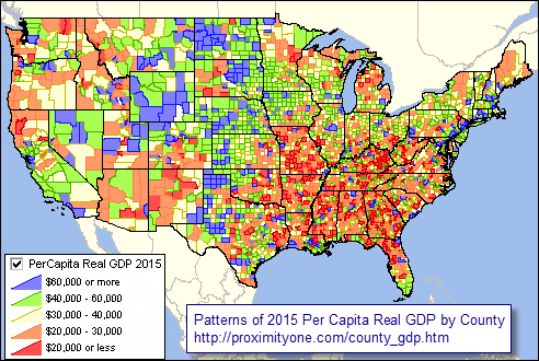
The graphic below shows patterns of per capita real GDP, 2015, by county.
– View developed using CV XE GIS and related GIS project.
– create custom views; add your own data, using the GIS project.
Gross Domestic Product (GDP) by county is a measure of the value of production that occurs within the geographic boundaries of a county. It can be computed as the sum of the value added originating from each of the industries in a county.
Example … use this interactive table to see that 2015 Los Angeles County, CA total real GDP of $656 billion was just slightly larger that than of New York County, NY (Manhattan) at $630 billion. Yet, the total 2015 population of Los Angeles County of 10.1 million is 6 times larger than that of New York County of 1.6 million — see about steps. GDP provides very different size measures, and economic insights, compared to population.
In 2015, real (inflation adjusted) Gross Domestic Product (GDP) increased in 1,931 counties, decreased in 1,159, and was unchanged in 23. Real GDP ranged from $4.6 million in Loving County, TX to $656.0 billion in Los Angeles County, CA.
This post is focused on U.S. national scope county level estimates of Gross Domestic Product (GDP) annually 2012 through 2015. This marks the first time county level GDP estimates have been developed, a part of the Regional Economic Information System (REIS). Use the interactive table to rank, compare, query counties based on per capita GDP, current GDP, real GDP by type of industry. Use the related GIS project to develop thematic map views such as the one shown below. See more about these data.
Current Annual Estimates & Projections
ProximityOne uses these and related data to develop and analyze annual Situation & Outlook demographic-economic estimates and projections. GDP items included in the table below are included in the “annual 5-year” projections as shown in the schedule of release dates; next release April 18, 2019 and quarterly.
Examining County GDP Using GIS Tools
Use the County REIS GIS project. Make your own maps; select different item to map; modify colors, labels. Zoom in views of selected states shown below. Graphics open in a new page; expand browser window for best view. Patterns: see highlighted layer in legend to left of map; MSAs bold brown boundaries with white shortname label
counties labeled with name and 2015 per capita real GDP
.. Arizona .. Alabama .. California .. Colorado .. Iowa .. Georgia .. Kansas .. Missouri
.. New York .. Nevada .. North Carolina .. South Carolina .. Nevada .. Texas .. Utah .. Vermont
Using the County GDP Interactive Table
The graphic below illustrates use of the interactive table. Tools below the table have been used to view only per capita real GDP for all sectors (total sources) and for county with total population between 50,000 and 60,000. Counties were then ranked on 2015 per capita real GDP (rightmost column).

– click graphic for larger view.
Using County GDP: Data Analytics Web Sessions
Join me in a Data Analytics Lab session to discuss more details about accessing and using wide-ranging demographic-economic data and data analytics. Learn more about using these data for areas and applications of interest.
About the Author
— Warren Glimpse is former senior Census Bureau statistician responsible for innovative data access and use operations. He is also the former associate director of the U.S. Office of Federal Statistical Policy and Standards for data access and use. He has more than 20 years of experience in the private sector developing data resources and tools for integration and analysis of geographic, demographic, economic and business data. Contact Warren. Join Warren on LinkedIn.
