
.. census blocks are the smallest geographic areas for which decennial census data (and data from any Federal statistical program) are tabulated. Census blocks are geographically defined by the Census Bureau in coordination with local agencies. For Census 2010, there were a total of 11,078,297 census blocks covering the U.S. wall-to-wall. 541,776 of these blocks are water blocks, mainly located in coastal areas. Approximately one-third of all census blocks have zero population. See more about accessing and using census block demographics in this related Web section
Related New York City posts:
– Manhattan Financial Sector Earnings – monthly/quarterly attributes
.. examine establishment characteristics by type of business
for any New York City borough or the metro
– NYC Chelsea area and demographic analysis
– Patterns of Block Group Income Inequality
.. illustrative applications in Pelham, NY vicinity; north of NYC & NYC overall
Census block data are important to demographic/market analysis in part due to the data being counts of population and housing units rather than estimates (subject to errors of estimation). Block data are also important due to their geographic granularity, very detailed geography. Block data provide a good way to aggregate small area demographics into territories, markets and service areas using GIS tools. We have not only demographic data for blocks but also their geographic attributes: location/boundary and area. Make maps and perform geospatial analysis using census block shapefiles. Use census block geography with non-census data for wide-ranging analyses.
Largest Population New York City (NYC) Census Blocks
The following graphic shows the NYC Census 2010 census block having the largest Census 2010 population that is not a group quarters population block.
The Lincoln Center census block shown in the graphic (red boundary) has 4,067 population and 2,922 housing units.
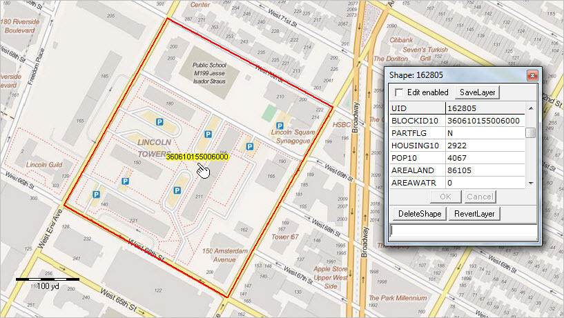
– click graphic for larger view; view developed using CV XE GIS
This block (36 061 015500 6000) occupies 0.033 square miles. It has a population density of 122,333 (population per square mile).
The NYC block with the largest population is on Rikers Island and has a group quarters population of 8,634 and 0 housing units.
For Census 2010, there were 350,169 census blocks covering the state of New York; 13,356 census blocks were water blocks. For the State of New York, as of Census 2010 the average census block population was 55 (57 excluding water blocks).
More about census blocks. In built-up urban areas, a census block often shares a boundary with a conventional 4-sided city block. Census blocks are normally bounded by roads and in some cases other types of physical boundaries. For Census 2010, each census block is coded as urban or rural; this is the basis for defining urban or rural population and geographies such as urbanized areas. See urban population and urban/rural ZIP Codes. Census block geography nest within block groups and census tracts.
Upcoming sections will focus on accessing, integrating and using New York City block group and census tract demographic-economic data. Unlike census blocks, annually updated demographic-economic data are available for block groups and census tracts from the American Community Survey.
About the Author
— Warren Glimpse is former senior Census Bureau statistician responsible for innovative data access and use operations. He is also the former associate director of the U.S. Office of Federal Statistical Policy and Standards for data access and use. He has more than 20 years of experience in the private sector developing data resources and tools for integration and analysis of geographic, demographic, economic and business data. Contact Warren. Join Warren on LinkedIn.
