
.. Geographic Information Systems (GIS) provide flexible and powerful capabilities to combine maps with data. Here we review easy-to-use examples of how you can do more with GIS tools. In our increasingly data rich environment, we often experience “drowning in data.” GIS tools can help harness disparate and voluminous data and assist with data linkage.
GIS provides us with a way to improve collaboration; we can more easily comprehend and understand geographic relationships and patterns among “variables.” As we reduce tabular data to visual representations, we are better able to communicate “what the data are telling us” among stakeholders and teams/committees. This second dimension, learning what the data are telling us, provides the power of creating insights for more effective decision-making.
Toward these ends, GIS applications provide dynamic map atlas/reference maps, thematic pattern maps and geospatial analysis capabilities. Examples of these three types of GIS applications are provided below. You can explore these applications on your own computer and modify the applications to meet your own geographic and subject matter needs.
1. Install the GIS Software and Project
• Install CV XE GIS (Windows-based computer)
• Create the folder c:\hawaii2014
• Expand GIS Project Fileset to c:\hawaii2014.
— requires ProximityOne User Group (join now, no fee).
• With CV XE GIS running, open the “Hawaii2014” GIS project
— File>Open>Dialog and select c:\hawaii2014\hawaii2014.gis
Start-up View: Honolulu:
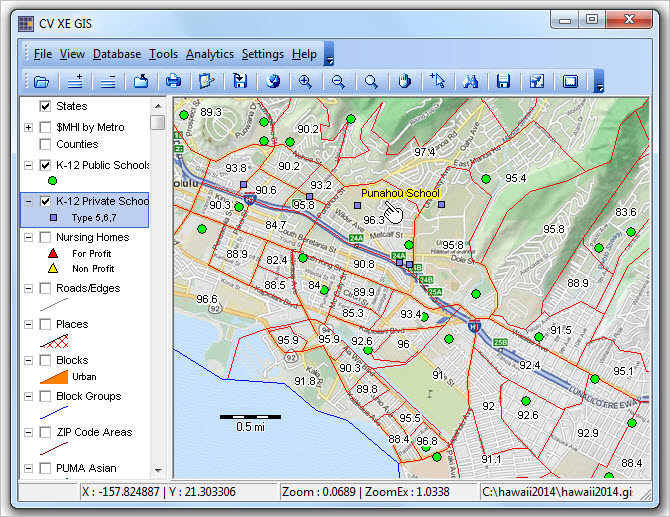
Click graphic for larger view.
See more about this GIS Project.
2. Making/Using a Reference Map
With CV XE GIS running, open the Hawaii2014 GIS reference project
— File>Open>Dialog and select c:\hawaii2014\hawaii2014_reference.gis
The start-up view (below) is a reference map of the Houston, TX area. One metro is selected using a query; counties are labeled. It is easy to see the counties that comprise the Houston metro, their names and locations. Try it yourself. Navigate to any metro.
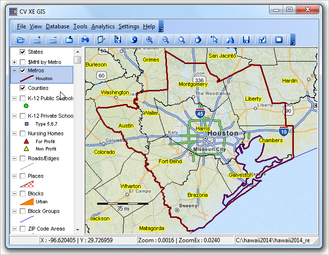
Click graphic for larger view.
3. Making/Using a Thematic Pattern Map
With CV XE GIS running, open the Hawaii2014 GIS pattern project
— File>Open>Dialog and select c:\hawaii2014\hawaii2014_pattern.gis
The start-up view (below) is a thematic pattern map of the 48 states showing metros by median household income. See color/value patterns in the legend at the left of the map panel. It is easy to see the how metros vary by median household income. Try it yourself. Change the colors/interval patterns. Label the metros with name. Zoom-in to any region. Add your own layers/data.
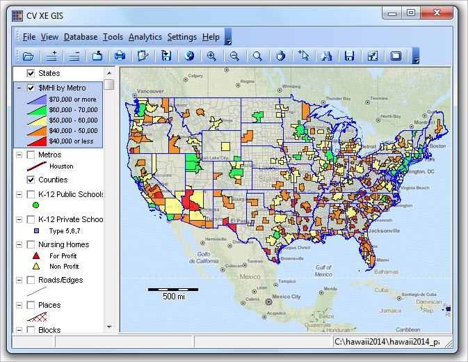
Click graphic for larger view.
4. Using Geospatial Analysis
With CV XE GIS running, open the Hawaii2014 GIS project
— File>Open>Dialog and select c:\hawaii2014\hawaii2014.gis
This is the basic GIS project; start SiteAnalyst: Analytics>SiteAnalyst.
The graphic below shows a site analysis view of schools selected by a circle. Attributes of the schools to analyze has been set to enrollment by grade (6 grades K-6 — upper right panel). As the selection is made, the schools are selected and enrollment summarized/aggregated (lower right grid). It is easy to see the aggregate enrollment by grade. Try it yourself. Select a different set of items to be aggregated. Select a different set of schools. Zoom-in to any area of interest. Add your own layers/data.
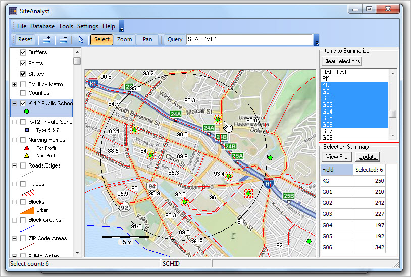
Click graphic for larger view.
Support Using these Resources
Learn more about demographic economic data and related analytical tools. Join us in a Decision-Making Information Web session. There is no fee for these one-hour Web sessions. Each informal session is focused on a specific topic. The open structure also provides for Q&A and discussion of application issues of interest to participants.

Pingback: Economic Prosperity by ZIP Code Area – My Money Advisor